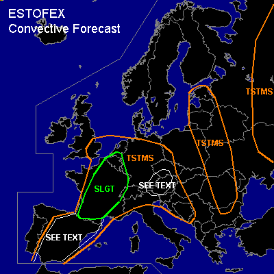

CONVECTIVE FORECAST
VALID 06Z THU 22/07 - 06Z FRI 23/07 2004
ISSUED: 21/07 19:17Z
FORECASTER: GATZEN
There is a slight risk of severe thunderstorms forecast across France, extremely northern Iberian Peninsula, Benelux, western Germany
General thunderstorms are forecast across Iberian Peninsula
General thunderstorms are forecast across SE-ern Germany, western Czech Republic, Austria, northern Balkans
General thunderstorms are forecast across SE-ern England, Germany, Alpine region, Balkans, Baltic States, eastern Poland, western Belarus, western and eastern Ukraina, western Russia
SYNOPSIS
Upper high geopotential axis is present from Algeria to eastern Alpine region and further to northern Russia ... and broad SW-erly upper flow remains to the west of this ridge axis. Over SE-ern Europe ... upper low-pressure system is centered over SW-ern Russia. During the forecast period ... a short-wave trough will cross Central Europe eastward. Two additional vort-maxima will cross Great Britain and N-ern France. At lower levels ... warm and unstable airmass remains SE of a line from central Iberian Peninsula to the Channel to northern Germany and further to the Baltic States.
DISCUSSION
...France, extremely northern Iberian Peninsula, Benelux, western Germany
...
Very unstable airmass is expected due to latest soundings. Steep lapse rates present over northern Iberian Peninsula and southern France should spread northward. Underneath the cap that is expected at the 850 hPa level ... low-level moisture should increase significantly during the next hours, and CAPE should likely reach up to 2000 J/kg during the day. In the afternoon ... surface low/convergence line is expected over central France due to insolation ... and low-level convergence, orographically enhanced UVM and strong insolation should lead to initiation. Initially weak vertical wind shear is forecast. However ... high CAPE values may be sufficient for supercells, though. Very large hail and damaging wind gusts will be likely with any supercell that forms. Thunderstorms are expected to cluster later on. In the evening ... upper jet streak is forecast over northern France ... and deep vertical wind shear/upward forcing will increase gradually. Due to decreasing LCL heights ... tornado threat seems to increase from central France to Benelux. A few tornadoes are expected. Thunderstorms may organize into a MCS that should move NE-ward reaching Benelux and western Germany later on. Severe wind gusts should be the main severe threat during the night hours.
...Iberian Peninsula
...
Steep lapse rates are present above the boundary layer over the western and central Iberian Peninsula. On Thursday ... insolation, orographically support, and weak upper forcing should be sufficient for isolated thunderstorms capable of producing large hail and damaging wind gusts. As deep vertical wind shear will be moderate, some rotating updrafts are not ruled out. Very large hail and severe downbursts are possible with any supercell that forms. However ... capping inversion may be too strong for initiation, and it is not clear that thunderstorms will develop. Due to high LCL heights and weak low-level wind shear ... tornado threat should be low.
...SE-ern Germany, western Czech Republic, Austria, northern Balkans
...
Weak vort-max will cross the region on Thursday ... and showers/thunderstorms are forecast along the low-level convergence line that should move eastward. Weak vertical shear is forecast. However ... isolated large CAPE should be possible ... and some thunderstorms may be strong, capable of producing isolated large hail or strong wind gusts.
#