CONVECTIVE FORECAST - UPDATE
VALID 14Z WED 21/07 - 06Z THU 22/07 2004
ISSUED: 21/07 14:31Z
FORECASTER: GROENEMEIJER
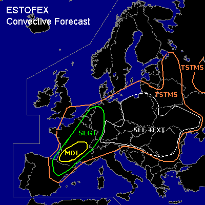
There is a moderate risk of severe thunderstorms forecast across parts of southern and central France
There is a slight risk of severe thunderstorms forecast across an area surrounding the moderate risk area including northern Spain, large parts of France, western Germany, western and northern Switzerland and parts of the Benelux countries
General thunderstorms are forecast across large parts of west-central, central and east-central Europe
SYNOPSIS
refer to convective forecast
DISCUSSION
...central and southern France...
A MCS over France moves towards the lower Loire Valley. To the south of the MCS
surface temperatures have reached 30 C with surface dewpoints of around 20 C.
Around 1500 J/kg of CAPE should therefore be present there.
Stronger than expected easterly low-level winds are observed north of the Pyrenees implying stronger-than-expected low-level convergence over southwestern France. Towering cumulus is visible on satellite imagery over the Aquitaine and Midi-Pyrenees regions. This suggests that convection may well intiate despite numerical models not developing much convective precipitation there. Deep-layer shear and storm-relative helicity are favourable of supercell storms. Expect development of a few supercell storms across soutwestern France that will be capable of producing large or very large (>4 cm) hail, and damaging winds, moving east or eastnortheastward. There is also a chance of a few tornadoes occurring. It seems likely that the storms cluster later on into one or more bow-echoes moving northeastward.
...Spain......
Despite the 12Z Zaragoza sounding showing a strong cap, convection has managed to intiate across the Pyrenees and the Ebro Valley. These storms may increase in coverage somewhat and some storms may become supercells. A threat of large hail and damaging wind will be present with these storms.
#