CONVECTIVE FORECAST
VALID 06Z WED 21/07 - 06Z THU 22/07 2004
ISSUED: 20/07 23:39Z
FORECASTER: GROENEMEIJER
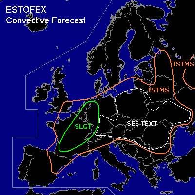
There is a slight risk of severe thunderstorms forecast across France, western and northern Switzerland, western Germany and parts of the Benelux countries
General thunderstorms are forecast across much of west-central, central and east-central Europe
SYNOPSIS
Wednesday at 06Z... a southwesterly flow at mid and upper levels is expected over western and central Europe. A weak NEwrd shortwave trough from SErn England to northern Spain is expected to be reach central Germany on Thursday morning.
DISCUSSION
...
France, Benelux, Germany, Switzerland...
A quite moist boundary layer is expected across the sligth risk area, with surface dewpoints generally in the 16-20 C range at 12Z. In response to solar heating... on the order of 1000 J/kg MLCAPE should be able to form over southern France as predicted by NMM22km/12Z. Rising motions ahead of the trough are expected to help scattered storms to initiate across the slight risk area. Deep-layer (0 - 6 km) shear is expected to be around 15 to 25 m/s with the strongest shear to the south. These values should be adequate to help storms organise into strong multicells and a few supercells, the latter being most likely in the southern 2/3rds of the risk area.
The storms will likely be capable of producing large hail and strong to severe winds. Additionally - although low-level shear does not look particularly favourable - one or two tornadoes cannot be ruled out. The storms will gradually cluster. It is well possible that an MCS forms over the Benelux during the afternoon and one or two over France or Switzerland more likely during the evening hours, that move eastnortheastward into Germany producing strong and severe winds.
..."SEE TEXT" area...
Scattered convective storms are expected to form in this area as some 500 - 1500 J/kg MLCAPE should become available in the area as the boundary layer warms. Since low wind shear is expected in these areas, storms should generally not become very well organised, except into clusters of single cells or along common outflow boundaries. Places seeing some upper-level support and therefore the greatest chance of larger clusters forming are northern, central and eastern Poland, Romania, Moldova and the western Ukraine.
Isolated large hail and strong winds will be possible across the entire area, but the overall threat is too low to warrant a risk category.
#