CONVECTIVE FORECAST - UPDATE
VALID 13Z TUE 20/07 - 06Z WED 21/07 2004
ISSUED: 20/07 13:26Z
FORECASTER: GROENEMEIJER
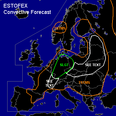
There is a slight risk of severe thunderstorms forecast across N-, Central and E-Germany, NW-Poland.
General thunderstorms are forecast across Central parts of Scandinavia, NE-Spain, Central and E-France, much of the Benelux countries, Central Europe and much of E-Europe.
SYNOPSIS
ref. convetive forecast
DISCUSSION
...Germany...
At 12Z... the baroclinic wave was located over northwestern Germany. Over northern Germany 5 m/s easterly surface winds are present. Low-level shear and SREH are quite strong over north-central and western parts of Germany as 10-15 m/s SWly winds are present there at 850, creating high 0-1 km SREH values. This in combination with 15 - 20 m/s 0-6 deep-layer shear and 200 - 300 m/s 0-3 km SREH suggests that the vertical wind profile should be adequate to sustain rotating updrafts.
Surface temperatures have risen to 22-25 C across central Germany and to 25-30 C in eastern Germany with rather high surface dew-points of around 18C, implying 1000 - 1500 J/kg 50hPa-MLCAPE should be present across eastern parts and somewhat lower values to the west, which is confirmed by the 12Z soundings.
A couple of storms have initiated across Thuringia and northwestern Bavaria. These and additional storms forming will probably cause some large hail and strong to severe wind events this afternoon. Given the distribution of low-level shear, highest tornado threat will likely be with the westernmost storms. Ingestion of boundaries laid out by earlier convection may aid tornadogenesis as well. Gradually the storms will likely cluster into a NEward moving linear MCS capable of producing severe gusts.
...Swtizerland, France...
Less forcing for upward motion that initially expected, marginal shear and low latent instability make that a slight risk is no longer needed for this area. However a few strong multicell or perhaps supercell storms producing some large hail and gusty winds cannot be ruled out.
#