CONVECTIVE FORECAST
VALID 06Z TUE 20/07 - 06Z WED 21/07 2004
ISSUED: 20/07 01:23Z
FORECASTER: HAKLANDER/GROENEMEIJER
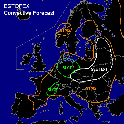
There is a slight risk of severe thunderstorms forecast across N-, Central and E-Germany, NW-Poland.
There is a slight risk of severe thunderstorms forecast across E-France and W-Switzerland.
General thunderstorms are forecast across Central parts of Scandinavia, NE-Spain, Central and E-France, much of the Benelux countries, Central Europe and much of E-Europe.
SYNOPSIS
A weak to moderate SW'ly upper flow should be present across much of Europe. During the forecast period, the mid-level vorticity maximum of an intensifying baroclinic wave should migrate NE'ward from C-France across the NW'rn half of Germany towards E-Denmark.
DISCUSSION
...Germany, and W-Poland...
In the warm sector of the aforementioned baroclinic wave, WAA of about 20-25 K/day at 850 hPa is forecast, and 0-3 km AGL SREH should increase from 100-200 m²/s² across W-Germany at TUE/06Z to 300-400 m²/s² across N- and NE-Germany at TUE/18Z. Across this area, significant upward forcing is forecast, which is thought to be favorable for a quasi-linear MCS. This MCS should move NE'ward across the NW'rn half of Germany. Convective activity is expected to intensify in the afternoon, when MLCAPE30 could reach 500-1000 J/kg, according to the NMM22km model. Deep-layer shear of 15-20 m/s is forecast across N-Germany, slowly decreasing towards the south. In addition to the strongly forced convection, other thunderstorms should develop during the day, probably multicells, but especially in Central and Eastern parts of Germany, some supercells are expected. Any supercell that forms could produce large hail, severe wind gusts and even a tornado. In the evening and overnight, strong forcing should still be present across NE-Germany and W-Poland and as the storms become elevated, severe wind gusts should become the main threat later on.
...E-France, and W-Switzerland...
According to GFS/12Z, about 1500 J/kg MLCAPE30 should build during the day. However, NMM4km, which covers this area, forecasts 700-1000 J/kg MLCAPE30, which seems more realistic. With 15-20 m/s deep-layer shear across the area, multicells could form. However, considering the modification of the low-level flow by orography, some storms might ingest enough SREH to become supercellular. Any supercell that forms should be capable of producing large hail and severe wind gusts and could spawn a tornado.
...The Czech Republic, Slovakia, S-Poland, W-Ukraine, and Belarus...
Vertical wind shear will be very weak throughout the troposphere, especially more to the east. According to Monday's GFS/12Z run, MLCAPE30 of 2000-2300 J/kg should build across the area. This is much more than the 500-1000 J/kg MLCAPE30 that is forecast by the NMM 22km model, which seems more realistic, considering similar values that were observed across E-Poland on Monday. With low CIN and 35-40 mm PW contents, convective activity should become quite widespread, with storms expected to cluster into multicells. Although large hail and severe wind gusts are possible with these storms, severe convective events should be brief and local, because of the absence of significant vertical wind shear and low to moderate CAPE.
#