CONVECTIVE FORECAST
VALID 06Z MON 19/07 - 06Z TUE 20/07 2004
ISSUED: 19/07 00:12Z
FORECASTER: GROENEMEIJER/VAN DER VELDE
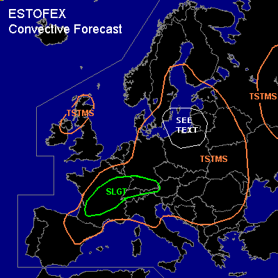
There is a slight risk of severe thunderstorms forecast across parts of France, Switzerland, Germany and Austria
General thunderstorms are forecast across Scotland, northern Ireland, large parts of western and central Europe, southern Scnadinavia, Belarus, the western Ukraine and the northern Balkans and across parts of Russia.
SYNOPSIS
A frontal zone an accompanying mid- and upper-tropospheric jet is located over northern France, northern Germany to the Baltic Sea. A baroclinic wave is developing ahead of an upper shortwave trough over the Benelux and western Germany. Its is expected to move ENEward rapidly reaching southwestern Finland at the end of the forecast period. A second trough is expected to move over northern parts of the Iberian peninsula during the morning and early afternoon and subsequently NEward into France.
DISCUSSION
...France...
In response to abundant solar heating over southern and central France,
500 - 1000 J/kg 50hPa MLCAPE should be able to form. On approach of the second shortwave,
forcing for upward vertical motion is expected to overspread the area and deep-layer shear is expected to increase to 20-25 m/s. Scattered storms ar expected to form during the end of the afternoon and the early evening. Given that shear is rather strong and some 200 m/s SREH
is expected, development of a couple of supercells seems likely. These will be capable of producing large hail and strong to severe wind gusts. Although the setup is not particularly favourable for tornadoes, a tornado or two cannot be ruled out near the frontal zone where
relatively low LCL and LFC heights are forecast. During the late evening and overnight,\the activity will likely cluster into an MCS that becomes elevated and moves northeastward into Germany and the southern Benelux. The severe threat should become much smaller by then.
...southern Germany, northern Switzerland...
Around 20 m/s 0-6 km deep-layer shear and 500 - 1000 J/kg of CAPE seems to be able to form across the region. Scattered storms that may develop rotating updrafts/become supercells
will be likely. Large hail should be the main threat, although a few strong winds should be possible as well.
...northeastern Germany, extreme southern Sweden, northern Poland,
Lithuania, Latvia
northeastern Germany, extreme southern Sweden, northern Poland,
Lithuania, western Latvia
...
Ahead of the first shortwave trough... an MCS is expected over the western Baltic Sea, southern Sweden and parts of northern Poland. This system will likely produce strong, locally severe winds. Ahead of it... more isolated storms are expected may develop
over Poland and Lithuania. It is not ruled out that soem storms develop rotating updrafts and produce some large hail and wind. The storms will likely affect
Poland and southern Sweden during the afternoon and Lithuania during the
evening hours and into the night.
#