CONVECTIVE FORECAST
VALID 06Z SAT 17/07 - 06Z SUN 18/07 2004
ISSUED: 16/07 21:38Z
FORECASTER: HAKLANDER
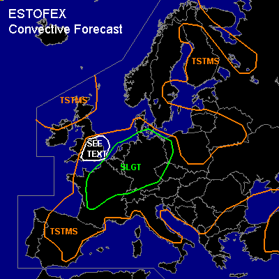
There is a slight risk of severe thunderstorms forecast across N-/Central France, the Benelux countries, and Germany.
General thunderstorms are forecast across The NW'rn British Isles, SE-England, much of N-, Central, and E-Europe, and Central Turkey.
SYNOPSIS
A large upper low NW of the British Isles and a broad ridge across Central Europe dominate the flow pattern across much of Europe. At 300 hPa, the polar jet stream meanders across Europe, with the jet axis across Britain and S-Scandinavia extending towards the Baltic States. This pattern should slowly shift E'ward during the forecast period. NWP models disagree on the exact behaviour of a short baroclinic wave in the SW'ly flow across W-Europe.
DISCUSSION
...N-France, Benelux, N-/Central Germany, NW-Poland...
Although GFS/12Z calculates much too high MLCAPE30 values of 2000-2500 J/kg across parts of the Benelux countries during Saturday afternoon and early evening, NMM22km/12Z indicates that CAPE should reach about 1000 J/kg during the day. The various numerical models do not agree on the possible sources of lift either.
GFS/12Z shows upward motion, associated with DCVA ahead of a weak, baroclinic wave at midlevels, that should move ENE'ward from N-France across Germany towards the SW'rn Baltic Sea. At the surface, a convergence line should develop during the afternoon, extending from NW-Germany towards SE-Germany at 18Z. This feature should move further NE'ward during the second half of the forecast period and might provide a trigger for storm development quite early in the afternoon across the Benelux and N'rn France. A small-scale SW'ly jetstreak of 15+ m/s at 850 hPa should also form across N'rn, Central and E'rn Germany later on, creating a set-up favorable for an MCS in the evening, especially since GFS/12Z places it in conjunction with a theta-e ridge at that level. This possible MCS should subsequently move into NW-Poland during the night.
The AFWA MM5/12Z run shows the same kind of scenario, but places the short wave, and the enhanced convective activity associated with it, farther west, mostly across the Benelux countries and NW-/N-Germany. It does show the German convergence line at 18Z, but also calculates a convergence line across NW- and Central France, extending towards the Netherlands. The UKMET/12Z run also has two convergence lines, with the strongest line across NW-France and the Benelux at 18Z.
Current thinking is, that multicells will form during the day across the area, with possibly the formation of an MCS across N'rn Germany, moving ENE'ward.
Considering the moderate CAPE, the storms are expected to be capable of producing large hail and severe wind gusts. The main convective mode will likely be multicells, with deep-layer shear below 15 m/s. However, 0-3 km SREH of 100-150 m²/s² should be present across much of the area, according to GFS/12Z. This might be sufficient to enable a few storms to become supercellular, especially where orographic effects come into play. Any supercell is likely to produce large hail and severe wind gusts. With low LCLs and 0-1 km shear approaching 10 m/s across the Benelux countries, tornado threat in supercells may be somewhat larger there than elsewhere in the SLGT region.
...SE-England...
Ahead of the approaching baroclinic zone, about 1000 J/kg of MLCAPE30 is forecast across SE-England during Saturday afternoon by GFS/12Z. With deep-layer shear of 15-20 m/s, storms might become organized. Even one or two supercells are not ruled out, although low-level shear should be higher to the north of the positive CAPE area. The NMM22km only forecasts 200-500 J/kg of CAPE, which does not seem enough to warrant a SLGT, considering the marginal shear conditions.
#