CONVECTIVE FORECAST
VALID 06Z THU 15/07 - 06Z FRI 16/07 2004
ISSUED: 14/07 20:42Z
FORECASTER: GATZEN
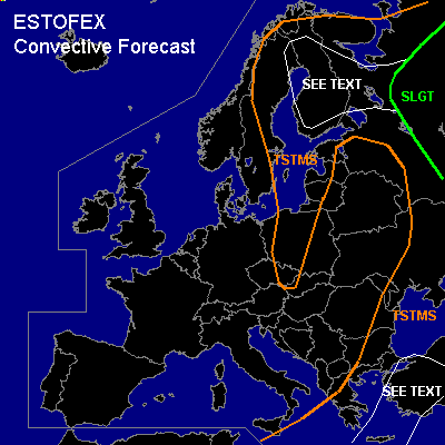
There is a slight risk of severe thunderstorms forecast across northwestern Russia
General thunderstorms are forecast across eastern Mediterranean and Turkey, extremely eastern Europe, eastern Scandinavia, the Baltic States, central Poland and eastern Czech Republic
SYNOPSIS
Rather strong westerly jet present over southern Great Britain and northern Germany. Amplified upper long-wave trough placed over eastern Europe and extends into eastern Mediterranean. At lower levels ... cold airmass has entered eastern Europe as well as the Mediterranean. Warm airmass spreads eastward over western Europe.
DISCUSSION
...Extremely northeastern Europe
...
Focus of Thursdays convective activity is expected east of the eastern European trough ... where warm and unstable airmass will be advected northward, as surface low attm N of the Black Sea is expected to move northward. Locally up to 1000 J/kg MLCAPE should be able to form in response to solar heating over northwestern Russia. Deep-layer shear around 15 m/s is expected over the area and should be sufficient for organized severe storms, including multicells and supercells that may cluster into a few MCSs. The storms will pose a significant threat of large hail and strong wind gusts. The latter will become more likely if MCSs will form later. In association with increasing low-level wind shear up to more than 10 m/s in the afternoon, a few tornadoes will be possible too, as relatively large amounts of low-level CAPE and locally low LCL heights are forecast.
...Turkey
...
In the range of the upper trough ... instable airmass is expected over the eastern Mediterranean. A rather strong jet streak is expected to spread over Turkey, where deep layer wind shear will likely reach more than 30 m/s during the day. If thunderstorms will form ... supercells will be possible due to strong vertical wind shear. Large hail and damaging wind gusts are expected with any supercell that forms. Rather weak low-level wind shear and relatively high LCL heights are forecast, limiting the chance for tornadoes. However, one or two tornadoes are not ruled out.
...Eastern Scandinavia
...
Slightly unstable airmass in association with rather strong deep-layer wind shear may be sufficient for organized convection. If thunderstorms will form, marginally large hail and damaging wind gusts are expected.
#