CONVECTIVE FORECAST
VALID 06Z WED 14/07 - 06Z THU 15/07 2004
ISSUED: 13/07 22:35Z
FORECASTER: GROENEMEIJER
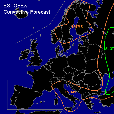
There is a slight risk of severe thunderstorms forecast across northern Turkey, the Black Sea, the Ukraine and parts of Russia
General thunderstorms are forecast across parts of Scandinavia, Italy, parts of the Balkans and large parts of eastern Europe
SYNOPSIS
Wednesday at 06Z.... a ridge is slowly moving eastward into western and southwestward Europe. A stationary mid/upper low pressure area is forecast over western Scandinavia. Over central to eastern Europe... trough is present with a core over the northeastern Balkans at mid-levels. A jet, initially over the Aegean Sea and western and central Turkey is moving northeastward over the Black Sea into the central Ukraine. Another jet is present over northwestern Russia.
DISCUSSION
...Russia, Ukraine, northern Turkey...
A surface low locasted over Moldova is eapected to move slowly eastward reaching the central Ukraine at the end of the forecast period. On its eastern flank warm and moist boundary-layer is advected northward. Dependent on the location of debris from earlier convection, locally between 1500 and 2500 J/kg MLCAPE should be able to form in response to solar heating. Deep-layer (0-6 km) shear around 20 m/s is expected over the area and should be sufficient for organised severe storms to form. These will likely include multicells and supercells that gradually cluster into a few large MCS's. The storms will pose a significant threat of large hail and strong winds. The latter will become more more likely as large storm clusters form later. A few tornadoes will be possible too, as relatively large amounts of low-level CAPE and locally low LCL heights are forecast.
#