CONVECTIVE FORECAST
VALID 06Z TUE 13/07 - 06Z WED 14/07 2004
ISSUED: 13/07 00:42Z
FORECASTER: VAN DER VELDE
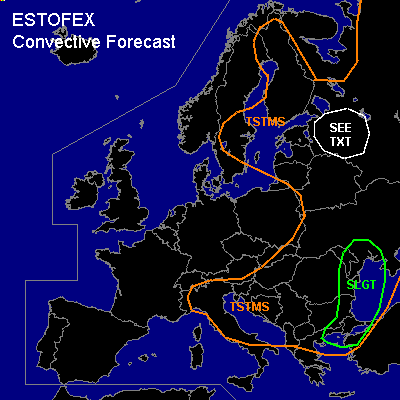
There is a slight risk of severe thunderstorms forecast across Ern Balkan, Moldova, Srn Ukraine, Wrn Black Sea
General thunderstorms are forecast across eastern portions of Europe
SYNOPSIS
A large upper trough dominates the weather in Europe, with shallower convection in Western Europe which is influenced more and more by a ridge of high pressure, and deeper convection at the warm theta-e side of the upper trough. Several wave disturbances will develop along the frontal zone in the eastern Balkan where a CVA maximum provides ample rising motion.
DISCUSSION
...Eastern Balkan area...
At the east side of the intensifying frontal zone, previous day's soundings (e.g. Bucarest) already indicated steep lapse rates and several hundred J/kg CAPE. GFS 18Z hints at CAPEs building up to over 1000 J/kg which seems feasible this time. Given the also moderate to strong deep layer shear/BRN shear and the tremendous amount of synoptic ascent near the CVA as it interacts with the frontal zone near eastern Romania, a large MCS is the most likely mode of convection. GFS conv precip shows large amounts that support widespread convection. A supercell or two may occur as well, especially since 0-3 km SREH values rise over 250 m2/s2. The primary theat will be severe gusts and large hail, but any supercell may be able to produce a tornado as well.
In the northern Aegean Sea, another wave is progged to develop with steep lapse rates and rising motions, and is also under moderate shear conditions. Dry midlevel air over this area as indicated in delta-theta-e fields by GFS should promote downdraft strength and thereby severe gusts at the ground.
...Southeast of St Petersburg, Russia...
A theta-e ridge is forecast by GFS to generate some CAPE. Steeper lapse rates seem indeed to be advected into the area, and moderate wind shear will be in place. GFS shows good amounts of low level CAPE, and not much low level wind which may on the other hand promote tornadogenesis by spin up of vertical vorticity. These phenomena should not be widespread.
.........
Attention should be paid to soundings with steep low level lapse rates and moisture, i.e. containing large low level CAPE. Under quiescent conditions, convection under these circumstances has an enhanced chance of producing funnels and sometimes land/waterspouts that may do damage. GFS model is often inaccurate about the location/intensity of buoyancy.
#