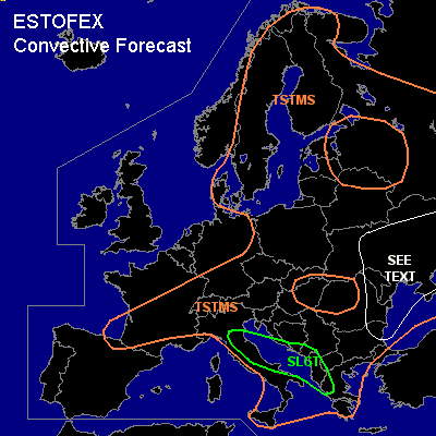

CONVECTIVE FORECAST
VALID 06Z MON 12/07 - 06Z TUE 13/07 2004
ISSUED: 11/07 23:37Z
FORECASTER: GROENEMEIJER
There is a slight risk of severe thunderstorms forecast across Adriatic Sea coastal areas of the western Balkans and eastern Italy
General thunderstorms are forecast across large parts of northern, central, southeastern and eastern Europe
SYNOPSIS
Monday at 06Z... at broad longwave trough is located over central europe. On its southern flank a westerly mid/upper level jet is located over the central Mediterranean. A shortwave trough over eastern Spain and southeastern France is expected to be near a line from the central Adriatic Sea to Sicily by the end of the forecast period.
DISCUSSION
...Adriatic Sea coastal areas of the western Balkans and eastern Italy...
Some latent instability is forecast ahead of the mid/upper trough approaching the area.
Rising motions ahead of the system are expected to cause initiation of convection during the afternoon and evening over the Adriatic and Italy east of the Apennines and perhaps over Sicily. Rather strong deep-layer shear suggests a few supercells can be expected that should be capable of producing large hail and strong to severe gusts. The convecton is expected to merge into a MCS that moves inland and become elevated overnight.
...eastern Balkans...
A few storms should be able to form in the area during the day and perhaps during the late evening and night as rising motions overspread the area in response to the approaching mid/upper system. Given that deep-layer shear is expected to increase to around 20 m/s (0-6 km), a few strong or severe possibly rotating storms could form. However, overall forcing for upward motion seems to be smal,l indicating that storm coverage will likely be low not warranting a risk category. However, storms that do form can produce large hail and strong to severe gusts.
...Ukraine, Moldova...
Although low- and mid- level lapse rates seem to be quite weak per latest radiosonde observations, some CAPE should be able to form over the area. Since mid-levels are dry and a rather deep boudary layer is expected, a couple of strong downbursts should be possible with the scattered storms that will likely form. The lack of high CAPE, strong shear or a strong forcing system gives the impression overall severe threat will be quite limited, not requiring a slight risk.
#