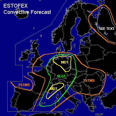

CONVECTIVE FORECAST
VALID 06Z THU 08/07 - 06Z FRI 09/07 2004
ISSUED: 07/07 23:48Z
FORECASTER: GATZEN/GROENEMEIJER
There is a moderate risk of severe thunderstorms forecast across southeastern France, northwestern Italy
There is a moderate risk of severe thunderstorms forecast across northeastern and northern Germany, extremely western Poland, extremely northwestern Czech Republic
There is a slight risk of severe thunderstorms forecast across most of Central Europe, northwestern Mediterranean
General thunderstorms are forecast across southeastern Great Britain, eastern France, Bay of Biscay, western Mediterranean, southeastern Europe, northwestern Russia
SYNOPSIS
West of weak developed upper ridge over the Mediterranean ... broad upper long-wave trough expands from Scandinavia to western Iberian Peninsula. One center is located over Scandinavia, the other west of France over the Bay of Biscay. The latter will move NNEward reaching the southern North Sea on Friday morning. Along the periphery of this trough ... unseasonably strong upper jet extends from the Atlantic to northern Iberian Peninsula and further to central France, pointing towards Benelux. This jet streak will intensify during the next hours over France where up to 60 m/s @ 300 hPa are forecast by GFS, while its axis should reach from the central Alps to eastern North Sea on late Thursday evening. In the range of this jet streak ... several short-wave troughs are forecast to move northward over Central Europe. At lower levels ... warm and unstable airmass ATTM over the western Mediterranean, eastern France, southern and southeastern Central Europe ... is advect northward east of an intense surface low over the Brittany. At some places ... well mixed mid-level layer is present from 900 to 600 hPa as indicated by Lyon LFLL 12 Z sounding. On Thursday ... strong upper jet streak will reach the Alps ... and lee cyclogenesis is expected north of the Alps, where the frontal boundary will be pushed westward. North of an approaching trough/vort-max, the deepening surface low is expected to move northward. However ... models are quite uncertain about the propagation of this low. On Friday morning ... GFS forecasts the center over the southeastern North Sea, while UKMO shows a easterly propagation to southern Baltic Sea. Upstream ... well developed short-wave trough/vort-max is expected over southern France on Thursday evening ... moving into central Germany until Friday, 06 Z. At low levels ... cold front will cross northern Mediterranean.
DISCUSSION
...Northern Italy, southeastern France
...
A cold front over the western Mediterranean is expected to move eastward and reach northern Italy during the evening hours. Ahead of the front, widespread convection is forecast as rising motions related to warm advection and DCVA move over the area. On approach of the front and a short-wave trough at mid/upper levels, deep-layer shear is expected to increase to around or above 35 m/s (0-6 km) and low-level (0-1 km) shear is expected to be around 10-15 m/s, while 0-3 km SREH should rise into the 200-400 m2/s2 range. In combination with 500 - 1000 J/kg CAPE per GFS model, and forecast low LCL heights, this creates a favorable setup for tornadic supercells across northern Italy during the afternoon and evening. Tornadoes that form in this situation may be strong. In addition to tornadoes, large hail and damaging winds will be possible. During the evening and overnight, the convection will likely merge into one or two MCSs, that will be capable of producing widespread damaging winds. Despite the impressive setup, rather low CAPE prevents the issuance of a HIGH risk at this moment.
...Western Czech Republic, eastern Germany, western Poland
...
ATTM ... severe thunderstorms move ESEward over SWern Germany and should affect central Germany during the night hours. On Thursday morning ... thunderstorms are expected over central Germany. East of a line reaching from south-central Germany to the southern Baltic Sea ... latest model output suggests almost clear conditions during the day and insolation is expected. North of the developing lee cyclone ... warm airmass should remain over eastern Germany and models suggest a well defined surface frontal boundary from Bavaria to northern Germany. To the east ... warm airmass ATTM situated over the eastern Alpine region will be present. Due to insolation ... low-level heating is expected, and boundary layer should locally mix out during the day. However ... CAPE is expected to reach up to 1000 J/kg. During the day ... increasing forcing north of the approaching vort-max is expected ... and thunderstorms should initiate over central Germany. Low-level southeasterly winds may create hodographs favorable for mesoclyclones during the afternoon/evening, and supercells are expected. Very large hail, damaging wind gusts and tornadoes are possible. However ... amount of instability is uncertain ATTM, as mid level clouds from Wednesday's convection may inhibit strong insolation. If stratiform clouds will remain over eastern Germany during the day ... chance for severe thunderstorms will be significantly lower than expected. In the evening ... convective activity will likely merge into a MCS and damaging wind gusts should be the main severe threat. It is not ruled out that a strong bow echo will form moving NEward affecting parts of northeastern Germany/northwestern Poland, as UMPL and BOLAM indicate a surface convergence line reaching across northeastern Germany. The chance for tornadoes will be enhanced due to low LCL heights and easterly surface winds north and east of the surface low over northeastern Germany/northern Poland. Well defined outflow-boundary may enter central Poland later on, where additional thunderstorms could be possible.
...Northeastern France, Benelux, and western Germany
...
Strong surface low is forecast to move northeastward and should be located over the channel by Thursday 12 Z. To the east and northeast of the surface low ... maritime airmass is expected. Low-level southerly to easterly winds to the west of the frontal boundary over Germany will likely advect moist/warm airmass into the affected region, and weak WAA is forecast. Latest model output does also show rather strong instability underneath the upper trough axis, and at the cyclonic flank of the approaching very strong jet streak ... DCVA should lead to UVM. Convection should form. Vertical shear profiles seem to be very favorable for supercells. Especially over Benelux and northwestern Germany ... tornado potential should be enhanced significantly as low-level wind shear will be strong ... and low LCL height are forecast. Large hail and damaging wind gusts will be possible with any supercell that forms.
...Alpine region
...
During the forecast period ... a strong vort-max will cross the Alpine region. To the east of the surface cold front ... föhn is expected that should lead to well-mixed and dry mid-level airmass. Models suggest instability due to insolation. As the cold front/upper short-wave trough approaches ... UVM should lead to thunderstorms. Very strong vertical wind shear is expected and supercells should be possible. Severe downbursts and large hail should be the main severe threat, while the chance for tornadoes will be slightly enhanced.
...Russia
...
The indicated area will likely see the development of thunderstorms during the day as up to around 1000 J/kg CAPE should be able to form in the area. 10-15 m/s deep-layer shear forecast in the area should allow for the formation of multicells capable of producing large hail and strong to severe winds.
#