CONVECTIVE FORECAST
VALID 06Z WED 07/07 - 06Z THU 08/07 2004
ISSUED: 06/07 23:40Z
FORECASTER: GROENEMEIJER
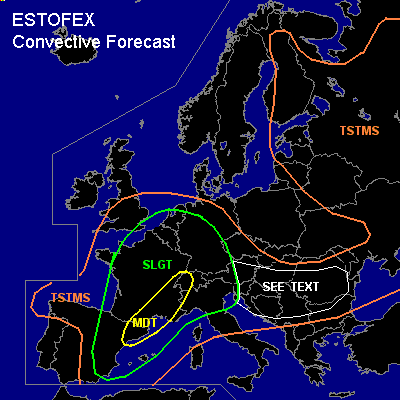
There is a moderate risk of severe thunderstorms forecast across northeastern Spain, southeastern France and western Switzerland
There is a slight risk of severe thunderstorms forecast across an area surrounding the MDT risk area including much of France, eastern Spain, the Alps, Italy, the Benelux and all but northern and northeastern Germany.
General thunderstorms are forecast across much of western and southwestern Europe and the northern Balkans as well as eastern Europe
SYNOPSIS
Wednesday at 06Z... a mid/upper low pressure system is expected around 500 km WSW of Brittany. A vorticity maximum embedded in a strengthening southsouthwesterly jet is initally expected over northern Spain, giving rise to strong rising motions and strong surface pressure falls ahead of it. As a result a surface cyclone is forecast form at the tip of a baroclinic wave that develops over western France.
DISCUSSION
...northeastern Spain, southeastern France and western Switzerland...
Some convection is expected to be ongoing within the warm sector over northeastern Spain as well as southern and southeastern France. Convection over the latter areas has an increasing chance of becoming severe during the day as shear profiles strenghthen. 500-1000 J/kg MLCAPE should be present near the Mediterreanen coast per GFS and rapid northward moisture advection through the Rhone valley should allow for the development of some latent instability furthern northward during the day. 25-35 m/s (0-6 km) deep-layer shear should be favourable for the development of supercells. The storms should be capable of producing damaging winds, large hail and some tornadoes, that may be strong (>F1). High, 300-500 m/s 0-3 km SREH values forecast over southeastern France and Switzerland per GFS 12Z are expected to be particularly favourable for updraft rotation and tornadoes.
...central and northern France, Benelux, Germany...
During the morning hours... it seems likely that a partially convective precipitation system ahead of the former vort. max. will be moving northward over western France. The warm front of the wave - expected to be initially near a line from Brittany to the western Alps, is expected to move northward and eastward to reach the northern Benelux and Germany by Thursday 06Z. Quite widespread convection is expected near and (elevated convection) ahead of the surface front, where up to 500 J/kg (elevated) MLCAPE should be available per GFS/NMM. Up to above 400 m2/s2 0-3 km SREH is forecast near the frontal zone, but some of the helicity will be present in the cool prefrontal air-mass that will not be ingested by storm updrafts. Nevertheless a potential for rotating updrafts seems to be present. Therefore, isolated (embedded) rotating storms are to be expected near the warm front, that - given anticipated low LCL heights - have the potential to produce tornadoes, that may be strong. Strong to severe gusts and some large hail are thought to be possible as well.
The storms -initially affecting France- will only very slowly reduce intensity during the evening and night, implying these will continue to pose a slight risk as they move into central Germany and the Benelux countries during the evening hours.
...northern Italy, Alps, Bavaria...
Despite the lack of a clear dynamic forcing mechanism, scattered storms are expected to develop over the Alpine flanks as some latent instability builds locally in response to
solar heating. Given the strong, around 20 m/s (0-6 km) deep-layer shear, some storms will likely become supercellular and be able to produce large hail and damaging winds. A tornado cannot be ruled out in this region.
...northern Balkans...
Isolated to scattered storms should be able to form as 500-1000 J/kg MLCAPE can form in the indicated area. Moderately strong shear profiles suggest storms can become well organised, including the possibility of a few mesocyclones forming. Large hail and strong to severe winds will be possible with the storms.
#