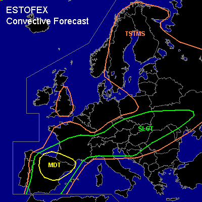

CONVECTIVE FORECAST
VALID 06Z TUE 06/07 - 06Z WED 07/07 2004
ISSUED: 05/07 22:44Z
FORECASTER: HAKLANDER
There is a moderate risk of severe thunderstorms forecast across NE'rn Spain and the Pyrenees.
There is a slight risk of severe thunderstorms forecast across the rest of Spain, S'rn France, Switzerland, Austria, N'rn Italy, Slovenia, Croatia, Hungary, the Czech Republic, Slovakia, S'rn Poland, W'rn parts of Ukraine, Moldova and N'rn Romania.
General thunderstorms are forecast across Central/S'rn UK, much of the Iberian Peninsula and France, much of Central and E'rn Europe, E'rn Norway, Sweden, Finland and the Baltic States.
SYNOPSIS
An upper trough across the eastern Atlantic slowly approaches western Europe. East of this trough, a strong SW'ly to W'ly upper jet extends from the Iberian Peninsula, across S'rn France, the Alps and S'rn Poland towards Ukraine.
DISCUSSION
...Spain, Pyrenees...
On the eastern flank of a long-wave upper trough on the Atlantic, a SW'ly jet streak at 500 hPa should intensify to about 35 m/s during the FCST period. Low-level cyclogenesis should take place across the Iberian Peninsula on the approach of the upper trough. In the warm sector of the associated baroclinic wave, a strong veering and increase of the wind with height should yield 200-300 m²/s² SREH in the lowest 3 km AGL. Furthermore, 1500-2000 J/kg SBCAPE is expected to build across N'rn, E'rn and Central parts of Spain. With about 25 m/s of 0-6 km AGL shear, conditions should become quite favorable for supercells, capable of producing large hail, damaging winds and tornadoes. With considerable upward forcing on a synoptic scale, storms might merge into an MCS later on, which can still contain embedded supercells. Especially across the NE'rn quadrant of Spain, low-level shear should become quite large, with 0-1 km AGL shear approaching 10 m/s, increasing to 12-15 m/s in the evening. Because of the colocation of high 0-1 km shear and low LCLs under favorable supercell conditions, current thinking is that some supercells will become tornadic.
...Bay of Biskay, France...
Strong upward forcing and positive CAPE will probably result in clustered thunderstorms later on in the FCST period, which might merge into one or two elevated MCSs during Tuesday evening and Wednesday night, when low-level shear should increase across the area. Largest threat will be severe wind gusts.
...Central Europe, N'rn Italy, Slovenia, Croatia...
With deep-layer shear of about 30 m/s in the north, any CAPE that forms could result in (mini-) supercells, capable of producing large hail, damaging winds and tornadoes. Shear appears to be most favorable to the north, while CAPE could exceed 1000 J/kg in the south.
...Austria, the Czech Republic, Slovakia, N'rn Hungary, W'rn Ukraine and Moldova...
A baroclinic wave should move eastward at 22-24 m/s, with maximum upward forcing at TUE/06Z near N'rn Austria, migrating eastward and reaching W'rn Ukraine/N'rn Moldova near 18Z. Monday's 12Z output of UKMET, GFS, AFWA MM5 and NMM model output did not exactly agree on the position of maximum forcing, but maximum resolved vertical velocities of < -75 hPa/h were forecast at 700 hPa. During the day, 500-1000 J/kg SBCAPE should form. Given deep-layer shear of 25-30 m/s and 0-3 km AGL SREH > 200 m²/s² in the wave's warm sector, storms could contain long-lived mesocyclones and may even spawn a tornado. Large hail and damaging wind gusts are possible with these storms as well. Convective activity is expected to become clustered and may merge into an MCS.
#