CONVECTIVE FORECAST
VALID 06Z MON 05/07 - 06Z TUE 06/07 2004
ISSUED: 04/07 23:30Z
FORECASTER: GROENEMEIJER/VAN DER VELDE
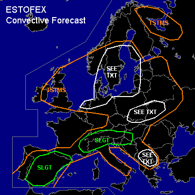
There is a slight risk of severe thunderstorms forecast across Spain, southeastern France, the Alps
General thunderstorms are forecast across much of central and eastern Europe, parts of southern Scandinavia, the British Isles, Iberia, and parts of the Balkans as well as Karelia and the Russian Murmansk adm. region.
SYNOPSIS
Monday at 06Z... a frontal zone is located from northwestern Spain over France and southern Germany to southern Poland. Along the frontal zone... a jet streak initally over France and Germany moves eastward during the forecast period reaching east-central Europe on Tuesday morning. A NE-SW'ly trough over the eastern Atlantic slowly approaches western Europe.
DISCUSSION
...Spain, Pyrenees, Southeastern France, Alps...
A well-mixed deep boundary layer is present over the entire slight risk area per today's radiosonde obersvations.
As low-level mass convergence and rising motions are expected to increase over the Iberian peninsula around 1000 J/kg MLCAPE is forecast to form in many places.
Locally higher values may be reached, especially over Spain across the Guadalquivir and Ebro valleys where influx of marine boundary layer moisture is expected.
Scattered storms are expected to form over the Iberian peninsula, southeastern France
and the Alps during the early afternoon. The highest coverage of storms is expected over northern Spain, where upward vertical motion should be the strongest per GFS and where storms will likely cluster into a mesoscale convective system.
Given that 15-25 m/s deep-layer (0-6 km) wind shear is expected over the area,
these will likely become multicell and supercell storms. Dry-mid levels and deep
a boundary layer will allow for the formation of strong downbursts with the storms.
Some storms will likely produce large hail as well.
...Poland, Ukraine...
Some deep convection will likely form over the area during the late morning and early afternoon. Since deep-layer (0-6 km) shear is expected to be around 20 - 25 m/s, some
storms may develop rotating updrafts. Where this occurs, a chance of large hail will exist
and a few strong to severe gusts may occur. The anticipated low CAPE of a few 100s of J/kg
and moderate amount of large-scale upward motion forecast over the area - that will likely cause the convection to have a rather low coverage - indicate that the overall severe threat should be quite limited.
...Central and southern Scandinavia, northern portions of The Netherlands, Germany and Poland...
An upper low collocated with a shallow sfc low is present and appears to be a classical synoptical setup for funnel clouds (occasionally landspouts/waterspouts). The low LCLs, amount of low level buoyancy and the weak shear/weak BL flow regime favor spin-up of vortices, preferrably along lines of convergent flow. Several spouts have already been reported in the past days.
...Serbia and Montenegro, F.Y.R. of Macedonia, western Bulgaria...
Solar heating of the boundary layer under a slightly conditionally unstable
troposphere should be able to produce about 500 - 1000 J/kg of MLCAPE50
across the area and a few storms should be able to form during the afternoon hours
as convective inhibition is expected to be small. A very dry mid-troposphere
should allow for a few downbursts with these storms. However given the low instability
and anticipated low coverage of the storms due to a lack of synoptic support,
the overall risk of severe weather seems to be quite limited.
#