CONVECTIVE FORECAST
VALID 06Z FRI 02/07 - 06Z SAT 03/07 2004
ISSUED: 02/07 07:47Z
FORECASTER: GATZEN
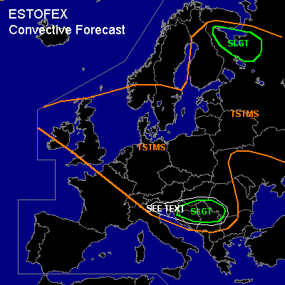
There is a slight risk of severe thunderstorms forecast across northwestern Russia
There is a slight risk of severe thunderstorms forecast across southern Balkans
General thunderstorms are forecast across northwestern Europe, Central Europe, southeastern and eastern Europe
SYNOPSIS
Unusual strong zonal flow remains over Europe ... and strong upper jet axis (up to 70 m/s@300hPa over France) is stretching from western France to southern Russia. Underneath this jet streak ... well defined low-level frontal boundary is present, dividing cold and convectively mixed maritime airmass to the north from subtropical airmass over the Mediterranean. Over the western Mediterranean, this airmass is characterized by mid-level steep lapse rates. Over extremely northeastern Europe, warm airmass is present.
DISCUSSION
...Balkans...
Warm and rather moist boundary layer will be present over the Balkans on Friday. Aloft ... steep lapse rates ATTM over Italy may spread eastward. During the day ... insolation should yield to sufficient instability up to 1000 J/kg. As strong upper jet streak approaches over the Alps, associated trough axis/vort-max will affect the northern Balkans, and DCVA should lead to UVM. Thunderstorms should form. Relatively strong vertical wind shear east of a surface low over northern Italy should be sufficient for organized convection, and supercells are possible with a slight chance of large hail, damaging wind gusts and a tornado or two. Convective activity should spread east- and southward later on, as surface cold front moves into the region leading to stabilization.
...Northern Italy...
Cold airmass is expected to spread into northern Italy west of a surface low. To the east ... low-level airmass will remain moist and warm. However ... weak synoptic forcing and capping inversion should inhibit thunderstorm initiation. If thunderstorms will form ... strong vertical wind shear will be sufficient for supercells. Best chances will be over northeastern Italy. Large hail, damaging wind gusts and a brief tornado or two are not ruled out if supercells will form.
...Extreme northeastern Europe...
In the range of warm and convectively mixed airmass ... thunderstorms are likely during the day due to insolation and UVM north of approaching negatively tilted short-wave trough. Strong low-level wind shear and moderate deep vertical wind shear will remain ... and thunderstorms should organize into supercells/multicells. Large hail, damaging wind gusts and a few tornadoes are forecast. Convection may merge into a MCS later on, enhancing the threat for severe wind gusts.
#