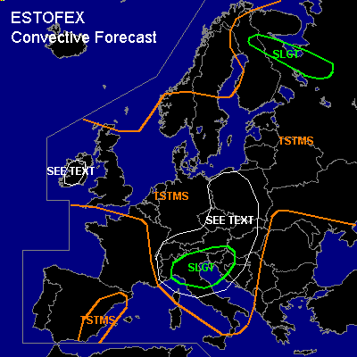

CONVECTIVE FORECAST
VALID 08Z THU 01/07 - 06Z FRI 02/07 2004
ISSUED: 01/07 07:53Z
FORECASTER: GATZEN
There is a slight risk of severe thunderstorms forecast across Northern Italy, northern Balkans, southern Austria
There is a slight risk of severe thunderstorms forecast across Northeastern Scandinavia
General thunderstorms are forecast across northern Central Europe, northwestern Europe, southern Scandinavia, eastern Europe, northern Mediterranean, eastern Iberian Peninsula
SYNOPSIS
Intense upper long-wave trough is placed over northwestern Europe, yielding a strong westerly flow with embedded short waves from France to southern Russia. A very strong (50 m/s@300hPa) jet is expected to reach the Alpine region on late Thursday. At lower levels ... well mixed airmass originating from the Iberian Peninsula has spread eastward across western Mediterranean. This warm airmass is advected northeastward east of the approaching jet streak and should affect Italy and the Balkans. To the north ... rather cold airmasses are present over Europe except for northeastern Europe, where easterly winds advect warm airmass into northern Scandinavia.
DISCUSSION
...Northern Italy, Balkans, southern Austria
...
Latest soundings over southern France and northwestern Italy show that well mixed airmass is entering the region. Over northern Italy ... rather moist low-level airmass is present, that may be preserved underneath the capping inversion, and CAPE up to 1500 J/kg should be possible. During the day ... at the southern flank of approaching jet streak, deep layer wind shear will rapidly increase to more than 20 m/s. Embedded short-wave trough should lead to UVM ... and it is expected that thunderstorms will develop during the afternoon. Vertical wind shear will be sufficient for supercells ... and very large hail and damaging wind gusts are forecast. The chance for tornadoes will increase during the afternoon when low-level wind shear should increase east of deepening surface low over the northern Mediterranean. In the evening ... convection may merge into one or two MCS moving eastward into the Balkans. Severe wind gusts will be the main threat. However ... large hail and a tornado or two are not ruled out.
...Alpine region to eastern Central Europe
...
Occlusion/cold front of surface low over the North Sea will affect the region. Ahead of this front ... warm airmass is characterized by low-level steep lapse rates. Weak developed boundary layer moisture is present and CAPE should be limited to several 100 J/kg. However ... weak CIN and strong synoptic forcing should allow for thunderstorms along the front. Relatively strong deep layer wind shear will be present over the Alpine region and southeastern Central Europe ... and some storms may organize. If supercells will form, large hail, damaging wind gusts and a brief tornado are not ruled out. To the north ... deep layer wind shear will decrease significantly. However ... moderate low-level wind shear ahead of the cold front and increasing instability over Poland may be sufficient for mesocyclones and multicells. Large hail, strong wind gusts and a brief tornado are not ruled out. Convection may organize into an MCS along the cold front later on. However ... overall threat seems to be too low to warrant a SLGT RISK. Best chances for severe evolution should exist over the eastern Alpine region, where low-level moisture should recover during the day.
...Northeastern Europe
...
Over northern Scandinavia ... warm airmass is advected westward during the day. This airmass is instable yielding CAPE up to 1000 J/kg during the day as shown by numerical forecasts. Unfortunately, there is no sounding available that characterizes this airmass. However ... moderate low and deep layer wind shear are forecast and thunderstorms should form due to weak CIN in the range of the right entry region of upper level jet ... and may organize into supercells and multicells. There seems to be a significant tornado threat during the afternoon/evening hours as low-level wind shear will reach more than 10 m/s and LCL heights are expected to be quite low.
...Ireland
...
Moderate low-level wind shear, low-level instability underneath the upper level trough and low LCL heights are forecast. Thunderstorms that form may organize into shallow mesocyclones, and brief tornadoes and isolated large hail are not ruled out.
#