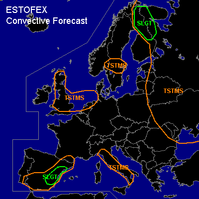
CONVECTIVE FORECAST
VALID 06Z WED 30/06 - 06Z THU 01/07 2004
ISSUED: 30/06 01:52Z
FORECASTER: VAN DER VELDE
There is a slight risk of severe thunderstorms forecast across northern Finland
There is a slight risk of severe thunderstorms forecast across eastern Spain
General thunderstorms are forecast across the UK/Netherlands
General thunderstorms are forecast across Italy
General thunderstorms are forecast across eastern Europe
SYNOPSIS
A decaying ridge over central Europe leaves weak presure gradients, and slightly low pressure over the Mediterranean. A thermal trough will linger over much of Spain. An old upper low resides over northeastern Europe where a surface low with high theta-e air at its north side progresses westward into Finland. An Atlantic low is slowly entering western Europe, with the associated cold front occlusion/wave (IR sat) moving through the UK, and north of The Netherlands on Thu morning.
DISCUSSION
...northern Finland...
strong low level wind shear over 20 kts with moderate deep layer shear and some instability at the theta-e plume and low LFCs indicate that an occasional tornado is likely.
...eastern Spain...
Strong convergence/uvv700 signal in GFS 18Z reacting to development of a thermal low with CAPE and moderate wind shear and some helicity seem to be supporting multicell thunderstorms, that might pose a slight risk of strong outflow winds due to the dry subcloud layer, and marginally large hail. However, the GFS model itself does not indicate convective precipitation which may indicate the cap may be too strong.
...Italy...
GFS indicates good amounts of convective precipitation, though the cap is strong. Low level convergence due to sea breeze circulation would likely allow enough lift to support a few thunderstorms. Enrainment of the present dry upper air can generate strong downdraft buoyancy which may lead to severe gusts at a very local scale. Vertical shear is weak and is not likely to support long-lived clusters of storms, although copious GFS convective rainfall may suggest otherwise.
...UK/Netherlands...
Vertical cross-sections (GFS) indicate that instability is only significant behind the occlusion, with little low level shear. Lift will increase in the left jet exit region over the southern North Sea as the jet over the Benelux intensifies by the end of the forecast period. This may initiate clustered TSTMS moving into Denmark.
#