CONVECTIVE FORECAST
VALID 06Z TUE 29/06 - 06Z WED 30/06 2004
ISSUED: 28/06 23:05Z
FORECASTER: HAKLANDER
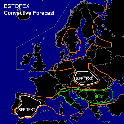
There is a slight risk of severe thunderstorms forecast across N/Central Italy, the N'rn Adriatic Sea, N'rn and Central parts of the Balkan Peninsula.
General thunderstorms are forecast across Spain and the Pyrenees, Corsica and Sardinia, Italy, the N'rn and Central Balkan, NW'rn Turkey, the Black Sea, Ukraine, W'rn Russia, Belarus, Estonia and Lithuania, Poland, the Czech Republic and Slovakia, N'rn Hungary, NE'rn Austria, N'rn Germany and the E'rn Netherlands, S'rn Scandinavia.
SYNOPSIS
The axis of a slightly meandering westerly jet with maxima near 50 m/s at 300 hPa is forecast near 50N, with a shortwave trough migrating across the N'rn and Central Balkan Peninsula on Tuesday.
DISCUSSION
...N'rn Adriatic Sea, N/Central Balkan
...
A baroclinically unstable wave is forecast to cross the Northern and Central Balkan Peninsula during Tuesday. In its warm sector, 250-300 m²/s² 0-3 km SREH is calculated by Monday's GFS12Z, along with 0-6 km deep layer shear approaching 25 m/s. Furthermore, strong forcing -- pressure velocities < -70 hPa/h at 700 hPa -- is present near the cold front of this rapidly moving system that should migrate E/ESE'ward between Tuesday 6Z and 18Z at a mean speed of 20-22 m/s. An important factor will be the amount of MLCAPE that will be available. According to Monday's GFS12Z, MLCAPE of 200-500 J/kg should form during Tueday afternoon. We believe that the synergy of maximum baroclinic wave development during late afternoon and strong wind shear will provide the right setting for severe organized thunderstorms. Because of the strong upward forcing, we expect organized nocturnal thunderstorms to be ongoing or new storms developing across the NW'rn Balkan during the early morning hours of Tuesday, moving E/ESE'ward during Tuesday. The QPFs of the GFS, MESO-ETA, MM5 and UKMET models agree on the path and intensity of the disturbance very well. The rapid migration of the VORTMAX and 0-3 km shear of 22-25 m/s seem to favor line convection, but considering the strong SREH and the strong deep-layer shear in the warm sector, some (embedded) supercells could also form, along or ahead of the cold front. In any supercell that forms, large hail, severe wind gusts and a tornado are possible. If a squall line manages to form, it could produce severe 25+ m/s straight-line winds, marginally severe hail and one or two brief tornadoes. At this point we cannot tell which mode will be dominant, but a SLGT seems to be warranted because of the general severe convective weather risk.
...N/Central Italy...
Monday's 12Z soundings across NE'rn Spain, S'rn France and NW'rn Italy indicated the presence of an EML, which should be advected towards N/Central Italy. Diurnal heating below this almost dry adiabatic profile could yield about 1500-2000 J/kg of MLCAPE and with 15-20 m/s deep layer shear across much of the area, we expect the formation of multicells and supercells. Moderate CAPE and WBZ heights near 3 km AGL imply increased large hail potential, especially in supercells. Furthermore, relatively dry air at midlevels indicates that entrainment will produce significant evaporational cooling and that there is an enhanced risk of damaging wind gusts with these storms.
...Iberian Peninsula...
Strong insolation should provide enough boundary layer heating and lift to overcome the CIN during late afternoon and early evening. Moderate MLCAPE, high LCLs and the presence of (very) dry air throughout most of the troposphere increase the potential for severe convective wind gusts with the storms that form; even one or two dry microbursts could occur. WBZ heights and low-level temperatures will most likely be too high for hail to reach the surface. Wind shear should be poor and considering that wind gusts should be brief and local, we refrain from issuing a SLGT.
...The Czech Republic, Slovakia, NE-Austria, N-Hungary...
Diurnal heating could yield a few hundred J/kg MLCAPE and given very strong deep-layer shear, one or two (mini-) supercells could form. If a supercell forms, large hail, severe wind gusts and even a tornado are possible. Severe convective events are expected to be isolated, so a SLGT does not seem to be warranted at this time.
#