CONVECTIVE FORECAST
VALID 06Z MON 28/06 - 06Z TUE 29/06 2004
ISSUED: 27/06 22:14Z
FORECASTER: GROENEMEIJER
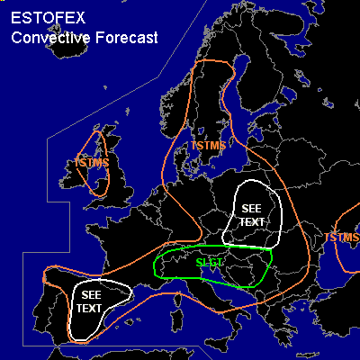
There is a slight risk of severe thunderstorms forecast across northern Italy and the nortwestern Balkans
General thunderstorms are forecast across northern and eastern Iberia, southern France, the Alpine countries, northern and central Italy, much of central Europe, the northern and central Balkans, parts of the southern Ukraine and across parts of Scandinavia and across parts of the British Isles
SYNOPSIS
Monday at 06Z... a slightly anticyclonically curved jet is located over western and central Europe. Downstream... a trough is located from southeastern Scandinavia to the central Ukraine.
DISCUSSION
...southeastern France, northern and central Italy, northwestern Balkans...
South of a frontal zone initially near a line from A Coruña to Bordeaux to
the Alpine massif to the eastern Czech Republic... abundant insolation will likely
allow for the formation of up to around 1000 J/kg MLCAPE in many places and
locally higher over northern Italy.
Forcing for upward vertical motion is expected to be quite limited over the entire
area during the afternoon, so storms are expected to be rather isolated. The
20-25 m/s deep-layer shear will however allow for the formation of supercells
capable of producing large hail and damaging winds. Most of the convective activity
should cease during the evening. An exeption will likely be over the Po-Valley,
as cyclogenesis in the lee of the Alps is forecast, that will induce rising motions there.
Widespread convection is expected over the Po-Valley and its surroundings
during the late evening and night. Here, somewhat higher low-level shear will
allow for an isolated tornado or two in addition to the hail and wind threat.
...Spain, Pyrenees...
Isolated storms should be able to form over Spain and the Pyrenees. Inverted-V profiles over the area
indicate that storms should be capable of producing strong to severe gusts locally.
...Poland, eastern Czech Republic, Slovakia, western Belarus, northern Hungary...
Ahead of a vorticity maximum embedded in the westerly mid/upper flow a few 100s J/kg of
MLCAPE could form during the day. As the vort max crosses Poland during the day
storms will likely iniate ahead of it. Given the rather strong shear, some storms
may develop rotating updrafts and produce strong to severe winds and some hail.
Given the rather low amount of CAPE expected, overall severe threat should remain
rather low.
#