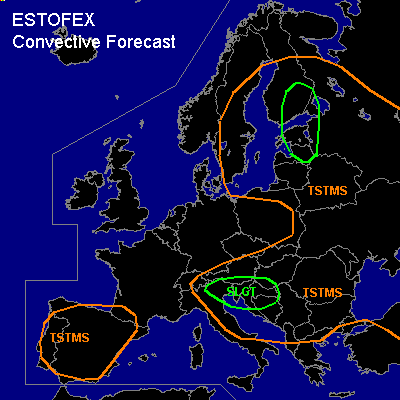

CONVECTIVE FORECAST
VALID 06Z FRI 25/06 - 06Z SAT 26/06 2004
ISSUED: 24/06 19:00Z
FORECASTER: GATZEN
There is a slight risk of severe thunderstorms forecast across Southeastern Central Europe, northern Italy
General thunderstorms are forecast across Eastern and NErn Europe, Iberian Peninsula
SYNOPSIS
Upper long-wave trough centered over southern Scandinavia slowly moves eastward. At its southeastern flank ... delta of strong upper westerly flow is present over southeastern Central Europe. Embedded vort-maxima are rotating along the trough moving negatively tilted into northeastern Europe. Over southeastern Central Europe ... another short-wave trough expands southeastward. At lower levels ... well defined frontal boundary divides cold and rather stable airmass in the range of the northern trough from warm subtropical airmass to the south from southern France to the Alpine region and further to central Russia.
DISCUSSION
...Southeastern Central Europe, northern Italy
...
Strong upper jet streak associated with approaching short-wave trough is forecast to move across the central Alpine region. At its eastern flank ... strong UVM is expected. Affected airmass should destabilize during the day indicated by latest soundings. Rather moist boundary layer airmass and relatively steep lapse rates aloft should allow for CAPE in the order of several 100s J/kg. At the surface ... frontal boundary is expected from northern Adriatic to southern Balkans. In the range of this boundary ... enhanced low-level moisture is expected, and CAPE may reach about 1000 J/kg. Surface convergence is also forecast, and thunderstorms should likely develop during the day. Strong deep vertical wind shear will be present, and supercells should form. Large hail and damaging wind gusts are expected with any supercell that forms. However ... due to low LCL height, the threat of tornadoes will be enhanced, and a few tornadoes seem to be possible in the SLGT RISK area.
...Northern Baltic, Finland
...
Rather strong upper southerly flow is expected over northeastern Europe. Embedded vort-maxima will move into the region during Friday. Art lower levels ... slightly unstable warm airmass is advected northward into northern Baltic states and Finland. Thunderstorms are expected that will likely organize as deep layer and low-level wind shear are moderate. If supercells may form ... the threat of tornadoes will be enhanced due to low LCL heights.
#