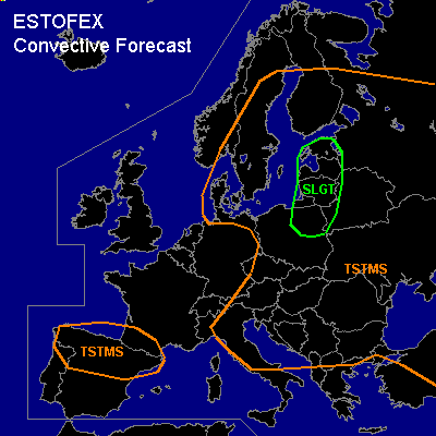

CONVECTIVE FORECAST
VALID 06Z THU 24/06 - 06Z FRI 25/06 2004
ISSUED: 24/06 07:06Z
FORECASTER: GATZEN
There is a slight risk of severe thunderstorms forecast across Baltic States, Nrn Poland
General thunderstorms are forecast across Eastern Europe, parts of SErn Central Europe, northern Iberian Peninsula
SYNOPSIS
South of deep geopotential over the northern Atlantic, strong westerly jet points to southern Central Europe. Delta of this strong jet is located SE of intense upper low centered over the North Sea. Several embedded vort-maxima are crossing Central Europe. To the east ... weak upper short-wave trough is present over SErn Europe slowly digging NEward. Over the Mediterranean ... anticyclonal flank of strong European jet will lead to stabilization.
DISCUSSION
...Central Europe, Nrn Europe
...
Intense upper trough will slowly move eastward reaching southern Scandinavia tomorrow. At its eastern periphery, upper short-wave trough/vort max moves eastward over eastern Europe. In the range of this feature, theta-e analysis shows relatively warm airmass characterized by rather moist low-level air, locally steep lapse reaches up to 2 km and convectively mixed airmass aloft, yielding CAPE in the range of several 100 J/kg. On Thursday ... thunderstorms are expected underneath the trough axis. Moderate deep vertical wind shear may be sufficient for organized convection. Current thinking is that at least a few multicells should form. Isolated large hail and strong wind gusts should be the main threat.
To the north ... strong southerly upper flow and embedded vort-maxima are expected. At lower levels ... unstable airmass is advected northward into the Baltic states. Thunderstorms are forecast. Strong deep layer wind shear and moderate low-level wind shear is expected, and thunderstorms should organize. Short bow echoes and shallow mesocyclones are not ruled out, with a slight chance of damaging wing gusts ... isolated tornadoes ... and isolated large hail.
In the range of the upper trough ... relatively cold convectively mixed airmass is present. However ... instability should be rather low as upper occlusion is expected during the day.
#