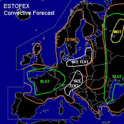

CONVECTIVE FORECAST - UPDATE
+ + + CORRECTED + + +
VALID 15Z TUE 22/06 - 06Z WED 23/06 2004
ISSUED: 22/06 15:57Z
FORECASTER: GROENEMEIJER
There is a moderate risk of severe thunderstorms forecast across Russian federation: Ivanovskaya, Yaroslavskaya, Vologodskaya, Kostromskaya adm. regions.
There is a slight risk of severe thunderstorms forecast across an area surrounding the slight risk area including much of western Russia, eastern Belarus, central and eastern Ukraine, and the western and northern Black Sea coastal zone.
There is a slight risk of severe thunderstorms forecast across much of France, the southern Benelux, west-central and southwestern Germany, extreme southern England.
SYNOPSIS
ref. convective forecast
DISCUSSION
...moderate risk area...
About 1000-1500 J/kg MLCAPE should be in place over the area, where clustering thunderstorms complexes have formed.
Today's 12Z soundings from Moscow and Suhinici show that a 20-25 m/s low level jet is currently located over
this area, so that a widespread damaging wind gusts with these rapidly moving thunderstorm complexes, that likely
exhibit bow-echo structures. In addition, large hail should be possible and perhaps an isolated
tornado or two. The activity should decrease overnight.
...central and eastern France, Germany...
Today's 12Z soundings suggest that a few 100's of J/kg MLCAPE50 are forming over much of France.
Strong lower tropospheric winds are expected to overspread much of France this evening while forcing for upward motion
increases. Numerical models suggest prefrontal convection will initiate over central/eastern France and move into central
and southern Germany during the night. Additional convection is forecast along the cold front that is expected to
be located from near Land's End to western Bretagne around 18Z, near a line from London to Calais to Bordeaux around 00Z
and from near Amsterdam to Luxembourg to near Biarritz at 06Z.
Anticipated strong 20 m/s low-level winds are expected ahead of the cold front
as it passes much of France and central/southern Germany, suggesting that severe gusts will likely occur in some
places. Additionally, forecast hodographs seem to be quite favorable
for the formation of rotating updrafts along and ahead of the cold front, as 200-400 m2/s2 0-3 km SREH and
near 200 m2/s2 0-1 km SREH should be in place. These favourable kinematics of the wind field in combination with
anticipated low LCL heights, suggest a couple of tornadoes will be possible.
Current thinking is that linearly organised convective systems will affect eastern France and southern/central
Germany this evening posing a threat of a few tornadoes and strong to severe wind gusts. A few isolated large hail
events should be possible as well. The forecast relatively low MLCAPE precludes the issuance of a higher category than SLIGHT risk.
...southern England, Benelux, northwestern France...
Quite a number of positive factors for tornado formation will likely be present over the area tonight.
Today's 12Z soundings suggest that some low-level MLCAPE is present ahead of the frontal system.
A sharp wind shift along the front implyies the presence of vertical vorticity
that may be stretched by forecast strong upward vertical velocities. Strong low level shear
could promote supercell-like updraft/downdraft couplets along the frontal zone.
Therefore, A few tornadoes will be possible as the front passes over southern England,
northwestern France, and into the Benelux countries. Additionally, strong to severe gusts will be possible
near and behind the frontal zone. Tornadic and wind threat are expected to be great enhough to warrant
a slight risk over the area.
...central Europe and northeastern Italy...
deep-layer shear of 15-20 m/s and around 1000 J/kg MLCAPE was observed by 12Z soundings in the region, suggesting a couple of strong multicells and perhaps a few rotating storms are possible in the area. Locally, some large hail and strong winds should be possible. Low storm coverage precludes the issuance of a risk category.
#