CONVECTIVE FORECAST
VALID 06Z TUE 22/06 - 06Z WED 23/06 2004
ISSUED: 21/06 22:19Z
FORECASTER: HAKLANDER
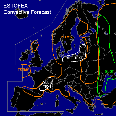
There is a slight risk of severe thunderstorms forecast across NW'rn Russia, E'rn Belarus, S/Central Ukraine, Moldova, E'rn Romania, E'rn Bulgaria, and NW'rn Turkey.
General thunderstorms are forecast across Scotland, the entrance of the English Channel, Sweden, much of Norway and Finland, Denmark, E'rn Germany, NW'rn Russia, E'rn Belarus, parts of Ukraine, much of the Balkan Peninsula, N'rn Spain, S'rn and E'rn France, the Alps, N'rn Italy, much op Poland and the Baltic States.
SYNOPSIS
A WSW'ly jet at 300 hPa across the Bay of Biskay bifurcates across France with a northern branch extending towards Poland and NW'rn Russia, where it is blocked by a strong upper high across Russia. The southern branch extends eastward into the Mediterranean. An unstable baroclinic wave SW of Ireland at TUE/06Z should rapidly intensify and migrate towards central/S'rn parts of the UK. Ahead of the associated cold front, strong theta-e advection at low levels should cause significant low-level frontogenesis across France. At WED/06Z, the cold front should lie across Belgium and Central France, towards NW'rn Spain. Another cold front at the western flank of the Russian upper high slowly migrates E'ward.
DISCUSSION
...SLGT region...
Monday's 12Z soundings show moderate MLCAPE of 1000-1500 J/kg ahead of the surface cold front, which probably reached a daytime maximum of 1500-2000 J/kg. Furthermore, dry air at midlevels was observed, with 1000 to 700 hPa theta-e decreases of 20-26K across the area. This implies an increased potential for evaporational cooling, where this dry air is entrained into downdrafts. Much change in the thermodynamic set-up is not expected. Significant 0-6 km AGL shear of > 20 m/s is only forecast outside the warm sector, in which most of the positive CAPE area should be situated. However, in the nortOn Tuesday, 1500-2000 J/kg MLCAPE should rebuild due to strong diurnal heating of the boundary layer, with highest CAPE across S'rn Ukraine. Owing to PW contents of 35-40 mm ahead of the cold front, high liquid water loading in downdrafts could provide an additional enhancement of convective wind gusts, which are expected to reach or exceed the severe limit of 25 m/s in some places. WBZ heights should be about 3 km AGL, and with LCL's mostly below 1.5 km AGL, MLCAPE should be sufficient to support the formation of large hail within a few storms. Towards the north end of the SLGT region, SREH should be enhanced due to strong WAA, and increased shear might support the formation of one or two supercells. With fairly low LCL's in that region, any supercell that develops might spawn a tornado.
...S'rn and E'rn France...
Strong theta-e advection at low-levels as well as solar heating should produce about 500 J/kg of CAPE in the course of Tuesday. At the approach of the aforementioned, strongly baroclinic system, deep-layer shear should increase to 20-25 m/s. Along with WAA-induced 0-3 km SREH of 200-300 m²/s², as well as local orographic effects of the Massif Central, thunderstorms that form in this area might become supercellular. Low LCL's and 10-15 m/s 0-1 km shear support tornado risk in any supercell that forms. However, CAPE seems to be too weak to warrant a SLGT.
...NE'rn Germany, N'rn Poland, Lithuania...
Diurnal heating within the polar air mass could yield upto 500 J/kg MLCAPE. Considering the presence of possibly 25 m/s deep-layer shear, one or two supercells might form, producing large hail, severe wind gusts and possibly a tornado. The set-up seems too conditional to warrant a SLGT at this time.
#