CONVECTIVE FORECAST
VALID 06Z SUN 20/06 - 06Z MON 21/06 2004
ISSUED: 20/06 00:46Z
FORECASTER: GROENEMEIJER/DAHL
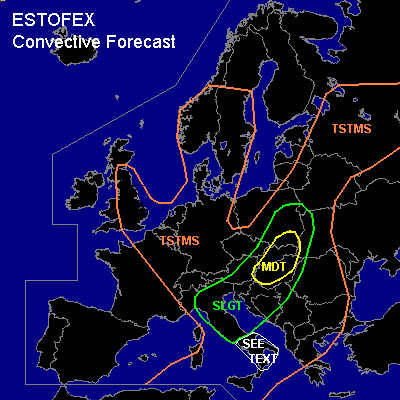
There is a moderate risk of severe thunderstorms forecast across Hungary, Slovakia and southeastern Poland
There is a slight risk of severe thunderstorms forecast across an area surrounding the moderate risk area including northern italy, the northwestern Balkans, parts of Austria, the Czech Republic and the Ukraine
General thunderstorms are forecast across the central Mediterranean, the Balkans, much of northwestern Europe, Belarus, the eastern Baltic States and parts of Russia.
SYNOPSIS
An extensive upper low is anchored over the North Sea ... with several perturbations rotating about its periphery ... the strongest of which is expected to cross N Italy and SE-central Europe during the day. Ahead of this feature ... low-level cyclogenesis is expected over Hungary/Slovenia late in the day along the low-level frontal boundary stretching from N Italy into the Baltic States. Several weak upper vorticity maxima are embedded in a southern upper frontal zone extending across S Iberia and the S Mediterranean.
DISCUSSION
...Northern and central Italy...
At 06 Z a mid/upper-level trough over the western Mediterranean and western Alps is moving eastward.
Strong rising motions are forecast over the southern Alps and the Po-Valley intially, sustaining widespread convection over the area where locally a few 100's of J/kg MLCAPE should be present. Rather strong (around 20 m/s 0-6km) deep layer shear may cause (embedded) supercells
among the convective activity. Therefore, a chance of large hail, strong winds and perhaps one or two tornadoes should exist during the morning hours and early afternoon over northern Italy, more isolated storms are expeted to form
southward over central Italy.
...northwestern Balkans, southeastern Austria, Hungary, Slovakia,
southeastern and eastern Poland, extreme western Ukraine....
Around 400-800 J/kg MLCAPE should be able to form over the northwestern
Balkans, while strong upward motions reaching the area from the west
will allow for rapid convective development during the early
afternoon. Given that shear profiles are expected to be quite strong,
scattered supercells should be occurring. These will be capable of
producing large hail and damaging winds. Since LCL heights
will be quite low and low-level shear is expected to be in excess of 10 m/s
a couple of tornadoes can be expected, of which some may be F2 or stronger.
During the afternoon and early evening the scattered convective activity is
expected to merge in a northeastward accelerating bow-echo that should be capable
of producing widespread wind damage over Hungary, Slovakia, southeastern Poland
and the extreme western Ukraine. Isolated tornadoes and large hail are not ruled out,
but the main threat should by that have shifted to severe straight-line winds.
...southern Italy...
Low-level moisture across the western and central Mediterranean is quite
variable as revealed by Saturday's radiosonde ascents ... some of them
showing deep enough moisture to support some CAPE ... locally exceeding 1000
J/kg. Models indicate patches of weak DCVA overspreading S Italy during the
day ... and with diurnal heating and orographic forcing ... chances exist
that an isolated TSTM or two will be initiated where sufficient moisture
will be present. If this happens ... kinematic parameters will be strong
enough to promote a few severe TSTMS with 850 hPa flow on the order of 10+
m/s. Main threat will be marginally severe hail and severe wind gusts.
Depending of the local shape of the low-level thermodynamic fields ...
low-level rotation may be promoted as well with the threat for a brief
tornado or two. However ... severe threat is quite conditional ... and
allover confidence in severe TSTM evolution is rather low ATTM ... and a
SLGT is not necessary.
#