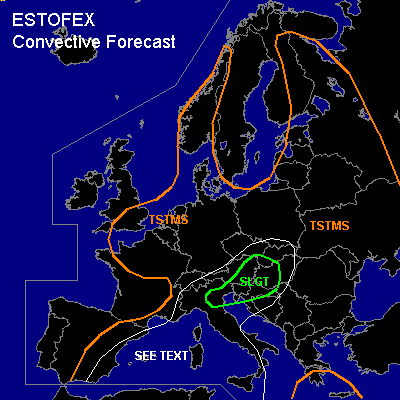

CONVECTIVE FORECAST
VALID 06Z SAT 19/06 - 06Z SUN 20/06 2004
ISSUED: 18/06 17:40Z
FORECASTER: GATZEN
There is a slight risk of severe thunderstorms forecast across northern Italy, Balkans, southern Austria
General thunderstorms are forecast across the Mediterranean, northern and northern Central Europe, eastern Europe
SYNOPSIS
Northern European intense long-wave trough remains while one center moves SWward reaching the North Sea on Sunday. Embedded trough axis/vort max ATTM stretching from SWern Scandinavia to central Great Britain will rotate around this center crossing northern Central Europe on Saturday. To the south of the long-wave trough ... rather strong upper flow will affect the Mediterranean. At lower levels ... cold airmass has spread over northern Europe north of a well defined frontal boundary evading from southern France and the Alpine region to northern Balkans and SWern Russia.
DISCUSSION
...Central Europe
...
Strong upper vort-max will cross Central Europe on Saturday. At its eastern flank, strong upper jet streak /90+ kts@300 hPa/ will propagate NEward reaching the Baltic Sea on early Sunday. Strong synoptic forcing is expected underneath the left exit region that will cross the southern Baltic Sea and southern Scandinavia on Saturday ... as well as underneath the right entry region that is expected over the eastern Alps. The northern UVM field will likely affect stable airmass of a occlusion, and thunderstorms are not expected. Underneath the southern UVM-field, well developed frontal boundary is present, and cyclogenesis is forecast. Warm airmass south of the frontal boundary is well mixed due to latest Udine ascend. If this airmass advects northward, CAPE may attain large values in the range of the warm front, where rich low-level moisture is present. Enhanced low-level helicity is forecast by GFS model output and mesocyclones are not ruled out. Large hail, damaging wind gusts and a few tornadoes are expected. To the west ... polar airmass will likely destabilize underneath the trough axis. Showers and thunderstorms are forecast. Weak instability and weak low-level wind shear are expected limiting the potential for organized convection. However ... rather strong deep layer wind shear underneath the flanks of the jet streak may enhance the potential for strong downdraft gusts. Small hail should be also possible with this convection.
...Western to central Mediterranean
...
Upper short-wave trough migrates from Iberian Peninsula to central Mediterranean. At its southern flank ... strong jet streak will move along the N-African coast. Model output suggests strong forcing just ahead of the approaching trough. At lower levels ... dry and mixed airmass originating from the Atlas mountains and the Iberian Peninsula will advect NEward, and steep lapse rates should likely spread over the region. Underneath the inversion ... boundary layer airmass is dry as indicated by latest ascends. On Saturday ... GFS model output suggests CAPE in the order of 1000 J/kg underneath the trough axis. This seems to be too optimistic, as low-level moisture was already overestimated today. Expect that instability will be significantly lower, widespread thunderstorms are not forecast. However ... isolated thunderstorms should initiate underneath the trough axis, and rather strong vertical wind shear may be sufficient for supercells. Large hail and damaging wind gusts will be the main severe threat. Convective activity will spread NEward reaching Sicily on late Saturday.
#