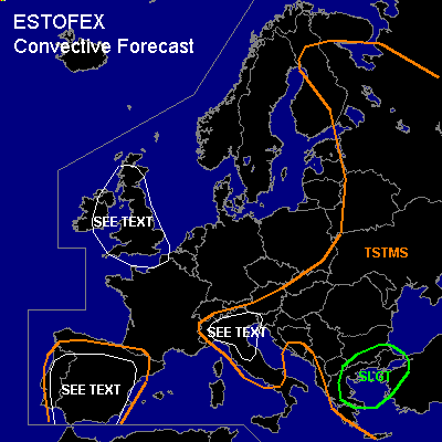

CONVECTIVE FORECAST
VALID 09Z FRI 18/06 - 06Z SAT 19/06 2004
ISSUED: 18/06 09:15Z
FORECASTER: GATZEN
There is a slight risk of severe thunderstorms forecast across Eastern Mediterranean
General thunderstorms are forecast across Northern Italy, Balkans
General thunderstorms are forecast across Iberian Peninsula
SYNOPSIS
Northern European trough expands westward as vort-max crosses northwestern Europe. With the mid-level jet at its southern flank, several weakening vort-maxima will propagate ENEward from western to northeastern Europe. Over the Mediterranean ... upper cut-off low will move eastward reaching Turkey at the end of the forecast period. To the west ... upper trough will reach the Iberian Peninsula.
DISCUSSION
...Eastern Mediterranean
...
Cut-off low weakens and continues to move eastward. At its southern flank, a relatively strong upper jet streak will reach western Turkey during Friday and DCVA is expected underneath the cyclonal exit region. At lower levels ... warm airmass is pushed eastward ahead of approaching cold front yielding CAA to the east of the approaching trough. Resulting UVM will be relatively weak due to latest GFS model output. Affected airmass is well mixed over the southern portions of the region, and CAPE will likely be quite low. To the north, rich low-level moisture is indicated underneath a capping inversion from northern Greece to northern Turkey, where CAPE reached 1000 J/kg on Thursday in the range of a stalling warm front. On Friday ... this low-level moisture may remain locally ... and CAPE may reach around 1000 J/kg. As the trough and associated cold front approaches ... thunderstorms should form. Relatively strong vertical wind shear will be present, and storms may organize. Supercells may form with an enhanced chance for large hail, damaging wind gusts and tornadoes especially in the range of the frontal boundary from northern Greece to northwestern Turkey. Over the southern portions, well mixed boundary-layer is expected and potential for downbursts should be enhanced.
...Northern Italy, Balkans
...
Rather strong upper jet is forecast along the southern edge of the European trough ... and embedded jet streak/vort max is crossing the Alps during the day. Downstream ... cyclogenesis is forecast over northern Italy, where surface winds should turn to southerly directions. Although synoptic forcing will be rather weak ... low level convergent flow is expected, and convection may initiate during the day, when insolation leads to instability. Affected airmass is characterized by moist boundary-layer and quite steep lapse rates aloft. If thunderstorms will form, rather strong low-level wind shear (GFS suggests 0-1km helicity around 100 m²/s²) will be sufficient for supercells, and large hail, damaging wind gusts and a tornado or two are expected. Over the Balkans ... thermodynamics will be comparable to northern Italy. However ... low-level wind shear and forcing will be lower. A few severe events are not ruled out.
...Iberian Peninsula
...
Dry and well-mixed airmass is present over the Iberian Peninsula. Approaching trough will lead to synoptic forcing. Due to insolation ... CAPE will build over the region ... and high-based thunderstorms should form. Deep vertical wind shear will increase over southern Iberian Peninsula, where strong upper jet is forecast. Some thunderstorms may organize with a slight chance for large hail and damaging wind gusts. Due to the dry and mixed boundary layer ... potential for severe downbursts is enhanced significantly over the Iberian Peninsula during the day. In the evening ... storms should decay due to stabilization.
...NWrn Europe
...
In the range of the upper trough ... weak instability will form over Great Britain during the day due to insolation. To the south ... deep vertical wind shear may be sufficient for organized thunderstorms. Expected airmass is indicated by Friday 00Z Albermarle sounding ... where low-level airmass is convectively mixed up to 700 hPa. However ... it is not expected that airmass over southern Great Britain will be mixed this deep ... and strong inversion will likely remain underneath the 700 hPa layer. Convection should be rather shallow ... and lightning should be rare. Due to low LCL heights ... shallow mesocyclones may produce brief tornadoes over the region. Overall threat seems to be too low to warrant a slight risk.
#