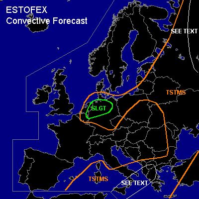

CONVECTIVE FORECAST
VALID 06Z THU 17/06 - 06Z FRI 18/06 2004
ISSUED: 16/06 17:24Z
FORECASTER: GATZEN
There is a slight risk of severe thunderstorms forecast across NW Central Europe
General thunderstorms are forecast across Mediterranean
General thunderstorms are forecast across parts of Nern Europe
SYNOPSIS
Intense long-wave trough is placed over Nern Europe. At its Sern edge, strong jet extends from Iceland to Great Britain, NEern Central Europe and further to NEern Europe. Embedded vort-maxima are present over Eern Poland, Scotland, and Iceland by late Wednesday evening and continue rotating along the edge of the main trough. Over the Mediterranean ... well developed cut-off migrates from Tunisia to Greece. At lower levels ... unseasonably cold airmass affects Nern Europe, while relatively warm maritime airmass enters NWern Europe in the warm sector of intensifying surface low. To the south ... well developed frontal boundary extends from west-central Russia to Nern Balkans and central France.
DISCUSSION
...Nern Europe
...
Several vort-maxima will be the focus of convective activity over Nern Europe. Over NEern Europe, a well developed short-wave trough migrates NEward leaving the forecast region till Thursday. However ... thunderstorms that form underneath the upper trough may be affected by deep vertical wind shear at the cyclonal flank of the upper jet ... and organized convection is not ruled out. Overall threat seems to be too low to warrant a slight risk. To the west ... another strong vort-max will reach Nern Central Europe ... and well developed surface low moves from Nern Great Britain to Sern Scandinavia. The cold front of this low pressure system is expected over Benelux and NWern Germany at 12Z. To the E ... warm sector airmass may destabilize due to surface heating: Upstream, Wednesday 12Z Brest sounding shows moist and warm boundary-layer airmass underneath an inversion that should be advect NEward into Central Europe. If mid-level cooling will be present due to the approaching upper trough, CAPE should build during the day. Strong forcing due to DCVA will be present and showers and thunderstorms are likely along and east of the cold front. 20+ m/s deep layer wind shear and 10+ m/s low-level wind shear are forecast and organized thunderstorms /short bows and shallow mesocyclones due to relatively weak instability/ may form. Strong or severe wind gusts should be the main threat. The chance for tornadoes will be significantly enhanced due to low LCL heights and locally enhanced low-level helicity in the afternoon when instability should reach its maximum. If supercells will form, isolated large hail is not ruled out. Although amount of instability is not certain ATTM, we decide to issue a slight risk for the affected region. An update may be warrant if instability will be lower than expected. West of the cold front ... showers and thunderstorms are forecast in the range of the upper trough. Strong low-level winds S of the surface low and strong vertical wind shear will be present, and organized convection is not ruled out. However ... instability will be weak due to latest GFS model output, and best chances for convection should exist over the Nern parts of the region. Small hail, severe wind gusts, and a tornado or two are not ruled out if thunderstorms will form. Further W ... a third vort-max will reach Great Britain late in the day. GFS does not indicate significant instability in the range of this vort-max. However ... if showers and thunderstorms will form, strong vertical wind shear over Nern Great Britain will be sufficient for organized convection. ATTM, it seems that thunderstorms will not form over the affected region.
...Central Mediterranean
...
Quite strong synoptic forcing is expected downstream of propagating cut-off low. A rather strong (50 m/s@300hPa) SWerly upper level jet streak is forecast from southern Tunisia to Greece on Wednesday evening. Strong DCVA is likely underneath the left exit of this jet streak. Just ahead of the approaching jet streak ... WAA is forecast from southern Italy to Greece, and strong UVM is expected due to GFS model output. At lower levels ... cyclogenesis is forecast over Sern Italy during the day, yielding low-level Eerly winds from the Balkans to south-central Italy. Deep layer wind shear should increase to more than 20 m/s over the affected region, and hodographs may be favorable for supercells. However ... amount of instability is questionable. Latest soundings do not indicate rich low-level moisture over most places, and mixing ratios are below 10 g/kg in the boundary layer. Aloft ... mid-level steep lapse rates up to 750 hPa are present over Sern Sicily. On Thursday ... low-level moisture may recover underneath a weak cap, and CAPE values may reach around 500 J/kg. Approaching trough should help to initiate thunderstorms along and NE of surface cold front to the S of the surface low. As vertical shear profiles will be adequate for organized convection, multicells and mesocyclones are not ruled out with an enhanced chance for large hail, damaging wind gusts and a tornado or two. Convective activity should spread Eward into Greece later on. ATTM, it seems that weak instability will reduce severe potential significantly. An upgrade to SLGT will be needed if rich low-level moisture will develop during the day.
#