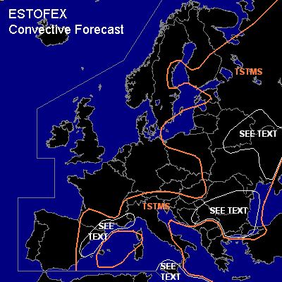
CONVECTIVE FORECAST
VALID 06Z WED 16/06 - 06Z THU 17/06 2004
ISSUED: 15/06 22:57Z
FORECASTER: GROENEMEIJER
General thunderstorms are forecast across parts of the western and central Mediterranean, parts of the Balkans and much of eastern Europe.
SYNOPSIS
Wednesday at 06Z... A slightly meandering jet stream is expected over northern Europe with a ridge over the British Isles and a broad trough over Belarus. A cold front is forecast along a line from the Russian-Ukranian border to Hungary to the Alps moving southward to reach the Adriatic, Bulgaria and the central Black Sea on Thursday morning. A sharp mid/upper trough is located from the northern Adriatic over the western Mediterranean to northwestern Algeria. This trough is expected to move slightly eastward and evolve into a closed low over Tunisia by the end of the forecast period. An intense shortwave trough is expected to move over the British Isles by Thursday morning.
DISCUSSION
...southern and eastern Belarus,
central Ukraine, Russian Bryansk,
Orlovsk, and Kursk adm. regions....
Along and behind the cold front, locally a shallow
conditionally unstable layer is forecast to be present
on the cold side of the surface front, as was the case on Tuesday at 12Z according to the soundings in Kursk (34009) and Kopenhagen (06181).
Rather shallow, and isolated somewhat deeper convection is forecast
to form, which will likele be thundery in some places. Given rather strong
20-30 m/s deep layer shear and around 10 m/s low-level shear, organisation of this convection mainly into short lines or bows is anticipated providing
a low risk of wind gusts near 25 m/s, mailnly small hail, and a small chance of a weak tornado or two.
...Balkans...
500-1000 J/kg MLCAPE should be able to form in respones to solar heating
before ahead and near the cold front that moves southward over the indicated area. Given that shear is forecast to be around 15 m/s a few well-organised multicell complexes should be able to form that should be capable of producing a few large hail
and strong wind events. Rather margianl instability and rather limited shear as well as the marginal upward motions predicted to affect the area preclude the issuance of a risk category.
...South-central Mediterranean...
Strong warm advection is expected on the eastern flank of the
trough/low moving towards Tunisia, causing strong rising motions.
A large MCS is forecast by numerical models affecting
the Thyrrenean Sea, western Sicily in the last hours of the forecast period.
Strong 20 m/s to 30 m/s deep-layer (0-6 km ) shear will particularly be present over and south Sicily, where a few isolated supercells should be possible.
These will likely be of an elevated nature, but
should be capable of producing large hail an perhaps a few strong to severe gusts.
Given that we forecast their occurrence around the end time of this forecast period, so that they may fall in the next period, and because the severe threat seems not to be particularly high we refrain from
issuing a categorical risk.
...eastern Spain, French Mediteranean coast...
Despite upper support being quite weak a few scattered storms could form over the coastal regions where a few 100's of J/kg uncapped MLCAPE are forecast.
Given the quite high deep-layer shear around 20 m/s, a few supercells could occur.
If this happens, isolated large hail and a few strong to severe wind gusts should be possible. Given the low instability and storm coverage a risk category is notissued for this area either.
#