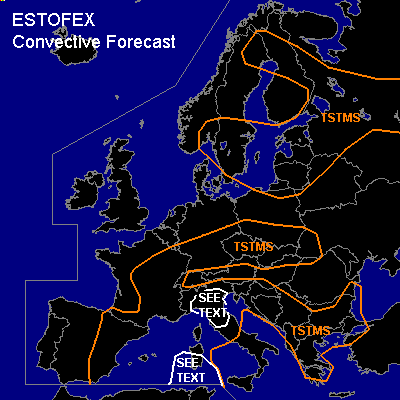

CONVECTIVE FORECAST
VALID 06Z TUE 15/06 - 06Z WED 16/06 2004
ISSUED: 14/06 20:40Z
FORECASTER: HAKLANDER
General thunderstorms are forecast across N'rn and S'rn Scandinavia, the Baltic States and NW'rn Russia.
General thunderstorms are forecast across E'rn parts of Spain, the Balearic Islands, E'rn and S'rn parts of France, S'rn Germany, S'rn Poland, the Czech Republic, Slovakia, Sardinia and the N'rn half of Italy, and much of the Balkan Peninsula.
SYNOPSIS
A slightly weakening but still unseasonably strong WNW-ly jet stream of 60-70 m/s at 300 hPa, should be located south of Iceland, across the Shetland Islands and N'rn Denmark towards the Baltic States at 06Z on Tuesday. During the forecast period, this upper feature should migrate SE-ward towards Central Poland. North of the Alps, along the NE'rn to E'rn flank of an Atlantic ridge at 45-50N, an air mass of maritime subtropic origin is advected SE'ward at lower levels. Across the Balearic Islands, an upper low progresses SE'ward very slowly. In the warm sector of a baroclinic wave on its SE'rn flank, high theta-e is advected towards Sicily at low levels.
DISCUSSION
...Western Mediterranean...
A few hundred J/kg CAPE should be available across much of the area, due to relatively cold air at midlevels. Since the air at midlevels is also quite dry, this implies increased potential instability. Therefore, bands of upward QG forcing through a deep layer are capable of destabilizing the air mass locally, producing convective bands ahead of the upper troughs that spiral around the main upper low. With in general less than 15 m/s deep layer shear and no significant low-level shear, the main convective mode will likely be multicells. Owing to evaporational cooling, storms may produce strong wind gusts. However, the risk of severe convective weather should be quite small, owing to the low-CAPE and low-shear environment. On the SE'rn flank of the upper low, deep-layer shear might become 20-25 m/s along the cold front, with about 100 m²/s² 1000-700 hPa in the warm sector of the aforementioned wave. Along with increased CAPE of about 800-1000 J/kg, supercells could form south of Sicily, but are not considered very likely. Because we expect the nature of these storms to be elevated, tornado risk should be very low, but large hail and severe wind gusts are less unlikely. A SLGT does not seem to be warranted, because of the fairly weak thermodynamic and kinematic setup.
...Northern Italy...
Diurnal heating could yield 1000-1500 J/kg CAPE in a very-low-shear environment, which is thought to be the right setup for strong pulse storms. Especially since very little flow is expected near the surface and relative humidities in the lowest km should be very high, convective updrafts will be less perturbed and could locally become very strong, possibly resulting in one or two brief tornadoes. Numerical models forecast a dry layer at midlevels, which increases evaporational cooling potential and hence the risk of severe wind gusts in downdrafts. Furthermore, WBZ heights as low as 2000-2500 m AGL indicate that large hail is very well possible within these strong pulse storms. Because severe convective events will likely be local and brief, we refrain from issuing a SLGT for this area.
#