CONVECTIVE FORECAST
VALID 06Z MON 14/06 - 06Z TUE 15/06 2004
ISSUED: 14/06 00:08Z
FORECASTER: GROENEMEIJER
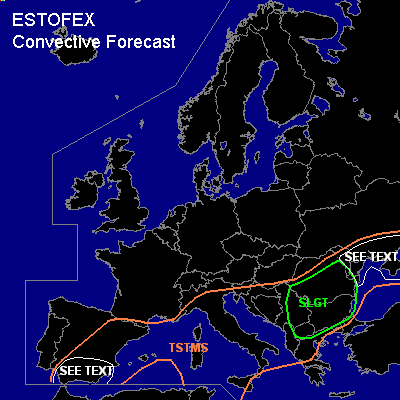
There is a slight risk of severe thunderstorms forecast across central and southern Romania, Bulgaria, the F.Y.R. of Macedonia and eastern Serbia and Montenegro
General thunderstorms are forecast across much of the western Mediterranean, Italy, the Balkans and the southern Ukraine
SYNOPSIS
Monday at 06Z... a vertically stacked low pressure area is forecast over northern parts of the Western Mediterranean and is expected to move southeastward as will a northeasterly jet over the Iberian peninsula. An initially stationary frontal zone is extending eastward from the northern Adriatic Sea over the northern Balkans to the southern Ukraine. Over northerwestern Europe a strong slightly anticylonically curved jet is rapidly overspreading much of Scandinavia the Baltic States and into east-central Europe.
DISCUSSION
...central Balkans...
An extensive cloud cover should be present in the area with some
convection still continuing. Where breaks in the cloud shield occur
for a longer time, MLCAPE in the 1000-2000 J/kg range should be able to form.
In combination with moderate (10-20 m/s) shear in place over the area, new
clustered multicells and possibly a few supercells will likely form,
posing a threat of large hail and severe gusts.
...Ukraine, Moldova, northeastern Romania...
South of the aforementioned frontal zone,
some CAPE may build over the Ukraine, Moldova and
northeastern Romania, if this area receives enough solar heating.
However, convective development downstream,
has produced an extensive cloud shield that will likely
inhibit heating. Nevertheless a few storms could form,
with highest chances over the Krim peninsula.
As deep-layer (0-6km) shear wil likely be near 20 m/s,
a few multicells and supercells should be possible,
yielding a risk of large hail and severe gusts.
The overall risk seems too low for a risk category.
...southern and eastern Spain...
As the northeasterly jet moves over the Iberian peninsula, deep-layer shear increases
strongly. A few storms could form over southern and eastern parts of the
peninsula where a few 100's J/kg MLCAPE should be able to form.
Multicells and supercells should be the main convective modes.
These will pose a threat of severe gusts because as the effects of strong evaporational cooling
and storm dynamics add up. Isolated large hail will be possible as well.
Given that MLCAPE is expected to be low and only a few isolated storms are expected,
the overall risk should remain below a slight risk.
#