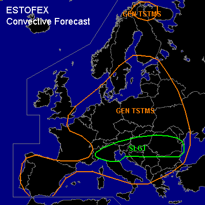

CONVECTIVE FORECAST
VALID 06Z SAT 12/06 - 06Z SUN 13/06 2004
ISSUED: 11/06 21:21Z
FORECASTER: GATZEN/DAHL
There is a slight risk of severe thunderstorms forecast across Northern Italy
There is a slight risk of severe thunderstorms forecast across SEern Europe
General thunderstorms are forecast across Central Europe, parts of Nern Europe, Iberian Peninsula
SYNOPSIS
Short-wave trough over NWern Europe migrates SEward reaching Central Europe on Saturday. To the west ... ridge amplifies over NWern Europe. Associated surface low builds over western Europe, pushing frontal boundary over Wern Europe southward. Over Eern Europe ... SWerly flow will remain. At lower levels ... frontal boundary will expand eastward.
DISCUSSION
...Northern Italy...
Impulse at the W periphery of the central European upper trough will rapidly migrate southwards into the N Mediterranean ... raching N Italy late Saturday night/early Sunday morning. Ahead of this trough ... low-level air mass currently over S France will be advected into N Italy. Though mid-level lapse rates will likely be fairly weak ... mixing ratios of 12+ g/kg will likely be present in the CBL ... sufficient to create CAPEs on the order of 1000 J/kg. Capping will likely be rather weak ... but convection may be suppressed until late Saturday afternoon in the wake of lead vort max which will graze N Italy early on Saturday. Deep-layer shear is FCST to increase to 20 m/s towards Saturday afternoon. Mesoscale model output offers SWLY SFC winds ... suggesting that low-level veering will need to be created locally by small-scale orographic features.
Current thinking is that numerous TSTMS will develop over N Italy towards late Saturday afternoon ... with chances of bowing line segments and mesocyclones ... the latter of which being conditional on the presence of low-level flow perturbations. Main threats will be large hail and severe straight-line winds ... though an isolated tornado cannot be excluded especially late in the day as LCL heights decrease.
...SEern Europe...
To the south of Eern European cold front ... warm and unstable airmass is advected Eward into Sern Belarus. This airmass is characterized by relatively moist boundary layer. To the south ... steep lapse rates are indicated by latest soundings. GFS model output suggests CAPE in excess of 1000 J/kg in the afternoon over SEern Europe. To the north ... upper level jet is expected from Sern Germany to Poland. Over SEern Europe, deep layer shear should reach 15 m/s at the Sern flank of the European jet. Small trough is forecast downstream of approaching jet, and synoptic forcing is likely. On Saturday ... thunderstorms should develop in the range of the frontal boundary. Some thunderstorms should organize given moderate deep layer wind shear. Multicells and supercells could form, and threat of large hail, damaging wind gusts and isolated tornadoes is slightly enhanced.
#