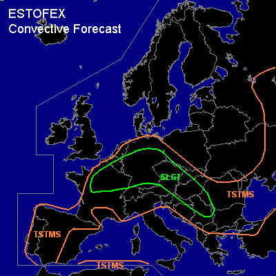

CONVECTIVE FORECAST - UPDATE
VALID 10Z WED 09/06 - 06Z THU 10/06 2004
ISSUED: 09/06 10:15Z
FORECASTER: GROENEMEIJER
There is a slight risk of severe thunderstorms forecast across northern France, the southeastern Benelux, much of Germany, Czech Republic, western Slovak Republic, eastern Austria, eastern Slovenia Hungary, eastern Serbia and Montenegro, western Romania
General thunderstorms are forecast across parts of Russia, the eastern and southern Ukraine, northwestern Turkey, much of the Balkans, central Europe, the Low Countries, France, the western and central Iberian Peninsula, northern Italy
SYNOPSIS
refer to convective forecast
DISCUSSION
...eastern Germany, Czech Republic, western Slovak Republic, eastern Austria, eastern Slovenia Hungary, eastern Serbia and Montenegro, western Romania
...
A bow-echo MCS is currently located over eastern Germany. It seems that the MCS could either re-intensify or a new MCS will form south of the current system as the upper level forcing responsible for the formation of the system moves into central Europe and MLCAPE should rise to around 1000 J/kg. Apart from this MCS, scattered strong to severe storms can be expected to form over the Czech Republic, the Slovak Republic, Austria and Hungary, where moderately strong shear will allow for the organisation of multicell and possible a few supercell storms, capable of producing large hail and strong gusts.
As mentioned, this activity will likely merge into a MCS moving southeastward, perhaps reaching Serbia and Montenegro and western Romania overnight. The main threat of this system will be severe wind gusts.
...much of Germany, northern France, southeastern Benelux...
Quite steep lapse rates were observed by 00Z and 06Z soundings in the area. In combination with observed 16-19 C low-level dew points more than 1000 J/kg MLCAPE should be able to form over the risk area. Despite shear being rather weak scattered storms producing large hail and a few strong gusts can be expected.
#