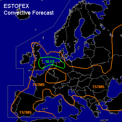

CONVECTIVE FORECAST
VALID 06Z TUE 08/06 - 06Z WED 09/06 2004
ISSUED: 07/06 23:05Z
FORECASTER: HAKLANDER/GROENEMEIJER
There is a slight risk of severe thunderstorms forecast across southeastern UK, southern North Sea, northern Netherlands, northwestern Germany
General thunderstorms are forecast across much of the UK, the North Sea, parts of the Netherlands, parts of Germany and Denmark, most of the Iberian Peninsula, western France, the Alps, northern Italy, central/eastern Europe, northern Balkan and much of Turkey.
SYNOPSIS
Along the Ern flank of a quasi-stationary ULL across the Northern Atlantic, warm and reasonably moist air is advected Nwd at low levels. A jet meanders from Ireland across the North Sea towards Belarus. Subsidence within an upper ridge across Ern France should surpress convective activity there, but large parts of the European continent are likely to see convection.
DISCUSSION
...England...
At 06Z... a diffuse north-south oriented cold front
is expected over Wales, that will likely move slowly eastward during the day.
Ahead of the cold front over much of England, solar heating should be able to warm te boundary layer
quite strongly in spite of some high clouds being present.
Expected surface dew-point temperatures of 16-18 C and temperatures near 25 C should allow for 1000 - 1500 J/kg MLCAPE to form on Tuesday. Some forcing for upward vertical motion should aid the formation of thunderstorms during the early afternoon hours. As 15-20 m/s 0-6 km shear is present, a couple of multicells are expected capable of producing scattered large hail and a couple of strong, possibly severe (> 25 m/s) wind gusts.
A few embedded rotating updrafts/supercells could occur as well. The activity should advect to the North Sea during the early evening.
...The Netherlands, NW-Germany...
A deep, conditionally unstable layer is present at mid-levels, providing a loaded-gun configuration as 1500-2000 J/kg MLCAPE will likely build below a capping layer during the day. Along a surface warm front across the Nrn/NErn Netherlands and NWrn Germany, low-level convergence might trigger a few thunderstorms. At this point, we think that convection will not develop before early evening, when CIN should be minimal.
Across the North Sea, an area of 30+ m/s deep-layer shear should be present, with the 20 m/s contour lying across the Nrn Netherlands towards Berlin. Of particular interest is a high-shear zone at low levels with its maximum across the Srn North Sea, extending across the Nrn Netherlands. Here, 0-1 km shear could reach 10-15 m/s, which should enhance rotation within convective updrafts. If thunderstorms form, they could become supercellular. Regardless of convective mode, WBZ heights of about 3 km AGL should be low enough to enable large hail to reach the surface, especially within supercells. Given the amount of latent instability and relatively dry air at mid-levels, convective wind gusts of >25 m/s should also be possible with any thunderstorm. Owing to quasi-linear upward forcing along the warm front, storms might cluster at nightfall and even merge into an MCS. With this scenario, severe wind gusts would become the main threat. Considering our uncertainty with respect to the amount of CIN and upward forcing, a SLGT is issued for the time being.
#