CONVECTIVE FORECAST
VALID 06Z MON 07/06 - 06Z TUE 08/06 2004
ISSUED: 06/06 23:33Z
FORECASTER: GROENEMEIJER
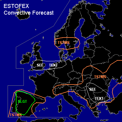
There is a slight risk of severe thunderstorms forecast across northern and western Spain and much of Portugal
General thunderstorms are forecast across the Iberian peninsula, southern Scandinavia, the Alps, the Balkans, southeastern Poland, the Slovak Republic and much of the Ukraine
SYNOPSIS
Monday at 06Z... a shortwave trough just west of Scotland is expected to move eastward rapidly on the northern flank of a broad quasi-stationary ridge over western continental Europe. A strong zonal polar jet is located over eastern Scandinavia and northern Russia. A weak longwave trough over the eastern Balkans is expected to move over the western Black Sea. A weak stationary mid/upper low is located over Morocco.
DISCUSSION
...Iberian peninsula...
Steep low and mid-level lapse rates have been observed
and are expected to remain in place over the Iberian peninsula.
Some low level moisture being present, solar heating
should help to build up about MLCAPE 1000 - 2000 J/kg MLCAPE.
As large-scale upward vertical velocities are expected to remain over the area ... scattered storms are expected to form.
The deep sub-saturated layer below the rather high cloud base
will allow for substantial evaporational cooling so that strong downbursts could occur. Some large hail is possible as well. A slight risk category seems therefore warranted despite the meager wind shear that is present.
...Wales, England, Low Countries, northwestern Germany...
As dew points reach 16-18 degrees across Wales and England and around
14-16 degrees in the Low Countries and northwestern Germany,
between 500 and 1000 J/kg MLCAPE should be forming in this area.
A deep warm an dry layer over the boundary layer is expected to prevent
deep convection from forming. There is a small chance of a few
storms forming near a weak front that approaches eastern England
and the northern Netherlands / Germany, where the cap should be weaker.
If storms form, hail and a few strong gusts should be possible.
However, this scenario seems quite unlikely so that we refrain from
issuing a categorical risk.
...Balkans...
More than 500 J/kg MLCAPE should be able to form over the
indicated area yielding a chance of some isolated mainly
2-3 cm hail events.
#