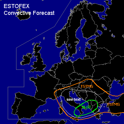

CONVECTIVE FORECAST
VALID 09Z THU 03/06 - 06Z FRI 04/06 2004
ISSUED: 03/06 09:05Z
FORECASTER: GATZEN
There is a slight risk of severe thunderstorms forecast across central Mediterranean, the Balkans
General thunderstorms are forecast across southeastern Central Europe
SYNOPSIS
European long-wave trough remains. Embedded strong vort-max ATTM over southeastern France moves southeastward into the central Mediterranean. To the east ... rather warm and unstable airmass affects the central Mediterranean and the Balkans.
DISCUSSION
...Central Mediterranean, the Balkans
...
Upper cut-off ATTM centered over NErn Italy moves southward. At its western flank ... strong upper vort-max ATTM over SErn France will reach southern Italy in the evening, pushing a relatively strong westerly jet streak southward into south-central Mediterranean. The exit of this jet streak is expected over NWrn Greece at the end of the forecast period. At lower levels ... cyclogenesis is forecast over Italy. To the west and south of the deepening surface low ... cold and dry low-level mistral winds are forecast from France to the Tunisian coast reaching Sicily during the day, while rather moist and unstable low-level airmass will remain over parts of the central Mediterranean, Itlay, and the southern Balkans. This airmass is characterized by weakly capped rich low-level moisture and local steep lapse rates aloft, and CAPE up to 1000 J/kg will be possible. Thunderstorms have already developed over Italy and the Adriatic, and should go on as approaching vort-max will lead to UVM. Low level southerly and easterly winds are forecast over the Adriatic and the Balkans just east of the deepening surface low. Aloft ... deep vertical wind shear will increase to the south, where upper westerly jet will likely reach more than 50 kts @ 500 hPa. Best shear profiles are expected over the southern Adriatic and the southern Balkans during the day, where supercells should be likely. Large hail, damaging wind gusts and a few tornadoes are expected if strong thunderstorms will form. However ... amount of available instability is still a question, as insolation will be limited due to low and mid-level clouds. During the evening ... focus of convective activity should spread northeastward into Greece and the Balkans. Stabilization after sunset should lead to weakening storms during the night hours. To the north ... vertical wind shear will decrease. However ... easterly surface winds and southwesterly wind aloft may create fovourable hodographs ... and isolated mesocyclones are not ruled out. Marginally severe hail and a brief tornado should be possible if mesocyclones may form.
...Southeastern Central Europe
...
North of the cut-off low ... warm airmass is advected northeastward. Thunderstorms may form. Organized thunderstorms are not forecast due to weak vertical wind shear.
#