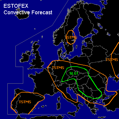

CONVECTIVE FORECAST - UPDATE
VALID 14Z TUE 01/06 - 06Z WED 02/06 2004
ISSUED: 01/06 13:56Z
FORECASTER: GATZEN
There is a slight risk of severe thunderstorms forecast across Eastern Central Europe
There is a slight risk of severe thunderstorms forecast across Southeastern Central Europe
General thunderstorms are forecast across see previous outlook
SYNOPSIS
Broad long-wave trough over Europe ... with several embedded vort-maxima. Narrow trough ATTM over central Germany cuts off during the next hours. Along its southern flank ... moderate jet streak (>50 kts @ 300 hPa) moves into southeastern Central Europe.
DISCUSSION
...Eastern Central Europe...
Latest water vapor image shows a dark stripe from central to southeastern Germany and further to the Czech Republic. GFS model output shows a narrow jet streak reaching from southern Germany to the eastern Adriatic and an associated vort-max in this region, that should reach the western Czech Republic in the evening hours. This jet streak is confirmed by latest ascend over Munich where 55 kts @ 400 hPa was observed. DCVA and weak warm air advection at the eastern flank of the trough should lead to UVM. At lower levels ... moist airmass has destabilized sufficiently due to insolation ... and CAPE in the order of 300 J/kg should be present. Showers and thunderstorms have developed underneath the trough axis und spread eastward. Easterly low level winds were observed and low-level veering should be sufficient for mesocyclones. Latest radar observations indicate strong thunderstorms and embedded multicells/mesocyclones over southeastern Germany and northern Czech Republic. During the next hours ... convective activity should spread eastward into southeastern Germany, the Czech Republic, southern Poland and probably northern Austria. Supercells should form due to favourable low-level wind shear. Main threat will be large hail and isolated tornadoes as LCLs are low. Over Bavaria ... right entry region of the jet streak may provide UVM during the evening. If easterly surface winds and instability will remain ... there will be a risk of thunderstorms and embedded mesocyclones. If supercells may form ... large hail will be the main threat. However ... a brief tornado is not ruled out.
...Southeastern Central Europe...
Widespread thunderstorms have formed over southeastern Central Europe. 12Z ascend over Zagreb shows weak deep vertical wind shear but low-level wind shear due to easterly surface winds. Some embedded mesocyclones may have formed, and large hail/isolated tornadoes are not ruled out. During the next hours ... UVM should spread eastward at the right entry of the upper jet streak and weaken due to latest model output. It is expected that convective activity will turn into non-severe mode in the evening hours.
#