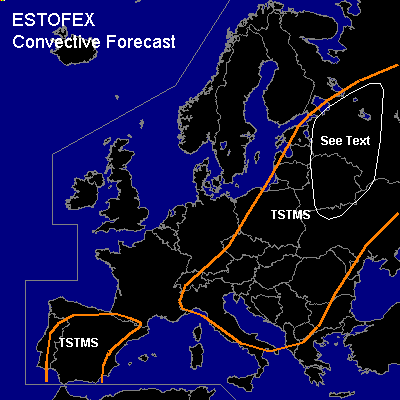

CONVECTIVE FORECAST
VALID 06Z FRI 28/05 - 06Z SAT 29/05 2004
ISSUED: 27/05 19:32Z
FORECASTER: GATZEN
General thunderstorms are forecast across northeastern Europe
General thunderstorms are forecast across Iberian Peninsula
General thunderstorms are forecast across southeastern Central Europe, north-central Mediterranean
SYNOPSIS
Broad upper long-wave trough over Europe slowly moves eastward ... and long-wave ridge expands into southwestern Europe ... pushing short-wave trough over the western Mediterranean eastward. Over northern Europe ... upper trough remains ... and vort-max ATTM over northern Germany will propagate southward reaching the Alpine region on Friday. At low levels ... cold airmass will remain except for the Iberian Peninsula.
DISCUSSION
...Northeastern Europe
...
West of a cold front ... modified and convectively mixed airmass enters eastern Europe. During the day ... insolation should lead to instability, and showers and thunderstorms are expected. Aloft ... a short-wave will propagate northeastward providing DCVA that should lead to UVM. Moderate deep layer shear will be present east of the trough axis ... and some thunderstorms may organize ... and multicells or mesocyclones are not ruled out. If supercells may form ... large hail will be the main threat. A brief tornado may form due to relatively low LCL heights.
...Iberian Peninsula
...
Relatively moist airmass will destabilize during the day ... and showers and thunderstorms are forecast. Weak shear and weak forcing will not support organized convection.
...Southeastern Central Europe, north-central Mediterranean
...
Modified polar airmass remains over the northern Mediterranean and the Balkans. This airmass should destabilize during the day. Propagating short-wave trough should reach the Alpine region late in the day ... and DCVA may support UVM. Showers and thunderstorms are expected. Deep vertical wind shear will remain weak over most of the region ... and organized thunderstorms are not likely. However ... well mixed boundary layer is present over the northern Mediterranean ... enhancing the potential for strong downdraft windgusts. Over the Alps ... rather moist and mixed airmass may destabilize during the day. UVM due to upslope flow and DCVA may be sufficient for thunderstorms. Weak shear and weak instability are forecast ... and severe thunderstorms seem to be not likely.
#