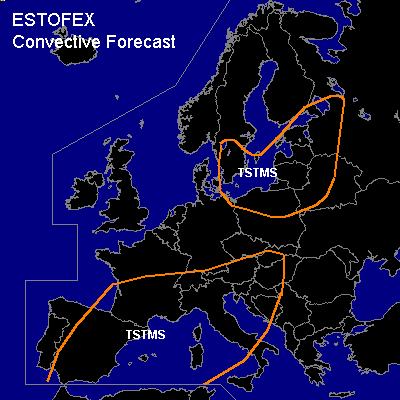

CONVECTIVE FORECAST
VALID 06Z THU 27/05 - 06Z FRI 28/05 2004
ISSUED: 26/05 19:53Z
FORECASTER: GATZEN
General thunderstorms are forecast across Southwestern Europe
General thunderstorms are forecast across Northern Mediterranean
General thunderstorms are forecast across Northeastern Central Europe
SYNOPSIS
Weak upper trough is analysed over Europe. Moderate mid-level flow is present at its southern flank over the southern Mediterranean. Embedded vort-maxima over northeastern Europe, northern Germany and northern Great Britain will propagate eastward. Over the western Mediterranean ... weak upper short-wave trough diggs eastward. At lower levels ... cold airmass is present over Europe ... to the south ... daytime heating has modified this airmass.
DISCUSSION
...Southwestern Europe
...
Over France and Spain ... modified polar airmass is present. This airmass is characterized by low-level steep lapse rates due to diurnal heating. Thunderstorms have developed today underneath the upper trough. On Thursday ... trough diggs eastward ... as short-wave ridge reaches the region from the west. However ... convection is expected during the day as strong insolation will lead to significant instability. If thunderstorms develop ... some strong downburst wind gusts may be possible. As soundings do not indicate very dry airmass over the affected region ... chance for severe windgusts seems to be quite low.
...Northern Mediterranean
...
Underneath the propagating trough ... some DCVA is expected over the Mediterranean. Strong heating over the land masses may lead to orographic induced convection. As deep layer shear remains relatively low ... and instability will be limited ... organized severe convection should be not likely.
...Northeastern Central Europe
...
DCVA will affect the Baltic States, Poland and northeastern Germany in the range of an upper vort-max. Mixed polar airmass will likely destabilize during the day. Showers and thunderstorms are expected. Deep layer shear will be not very strong in the range of the trough axis ... and as CAPE will remain quite low, severe thunderstorms are not forecast. Small hail should be possible due to low wet bulb zero heights.
#