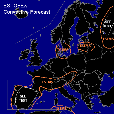

CONVECTIVE FORECAST
VALID 06Z WED 26/05 - 06Z THU 27/05 2004
ISSUED: 26/05 00:05Z
FORECASTER: GROENEMEIJER
General thunderstorms are forecast across much of southwestern continental Europe and the Alps
General thunderstorms are forecast across southern parts of the Western Mediterranean
General thunderstorms are forecast across southern Scandinavia and across the central Baltic States and northern Belarus
General thunderstorms are forecast across central Russia, the Vologda and Archangelsk adm. regions.
SYNOPSIS
Wednesday at 06Z... a closed upper low is expected over the north-central Ukraine. A jet streak on its eastern flank is moving northward. Upstream...a westerly jet over northern Germany is expected to move eastward. At low levels a cold front forms over central Europe, that moves slowly southward. Weak mid-level flow prevails over the central and western Mediterranean. A north-south oriented ridge over the western British Isles and the eastern Atlantic is almost stationary.
DISCUSSION
...Russia: Vologda, Jaroslavl and southern Archangelsk adm. regions...
Warm air is flowing northwardover the Don Valley and central Russia behind a northward moving warm front over the Vologda and Jaroslavl adm. regions at 06Z that moves into the southern Archangelsk adm. region. during the forecast period. GFS hints that around 400-800 J/kg MLCAPE are likely to form in the warm sector. Moderately strong deep-layer shear of 15 m/s to 20 m/s (0-6 km) should be present near the warm front, so that the anticipated convection near the
front may become organised. Strong low-level shear well in excess of 10 m/s and veering profiles indicate that short-lived rotating updrafts should be possible and
given low LFC heights a tornado or two cannot be ruled out. However, given the marginal amounts of CAPE and shear we will refrain from issuing a categorical risk.
...southwestern Europe...
Convection is expected to develop a diurnal heating warms the boundary layer over southern France, Spain and western and southern flanks of the Alps. Within the marked area over Spain MLCAPE may approach 1000 J/kg so that a few stronger gusts and some large hail should be possible.
#