CONVECTIVE FORECAST
VALID 06Z MON 24/05 - 06Z TUE 25/05 2004
ISSUED: 23/05 23:17Z
FORECASTER: GROENEMEIJER
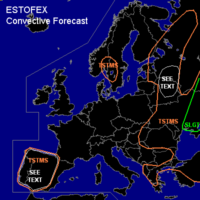
There is a slight risk of severe thunderstorms forecast across central and eastern parts of the Ukraine
General thunderstorms are forecast across parts of Iberia
General thunderstorms are forecast across southern Scandinavia
General thunderstorms are forecast across much of eastern Europe
SYNOPSIS
Monday at 06Z... an almost stationary mid/upper low pressure centre is located over Estonia. A NE-SW oriented trough from eastern Poland to Croatia is moving southeastward. A southwesterly jet (30 m/s @ 500 hPa) is located downstream of this trough. At the surface a cold front is located from the western Ukraine to central Bulgaria to southern Italy. The front is expected to move eastward reaching the central Black Sea Tuesday at 06Z, as a baroclinic wave develops over the central Ukraine. A closed high pressure system over western France is very slowly moving southeastward. A ridge is extending northward from the high over the eastern Atlantic Ocean.
DISCUSSION
...central, eastern Ukraine...
It seems as though the aformentioned cold front will move over the Black Sea before
storms can form over the eastern Balkans. However, further north over the central Ukraine
on the order of 400-800 J/kg MLCAPE will likely be able to form.
Convection may be able organise into multicell clusters, linearly organised convective
systems and supercells. Low LCL heights and quite strong low level shear indicate e
a few weak tornadoes will be possible. Additionally, the storms will be able
to bring some large hail and strong wind gusts.
...northern Belarus, Russian Pskov adm. region......
Between the core of the mid/upper low over Estonia and
the developing frontal wave over the Ukraine, a strong southwesterly jet
will be present providing 30-35 m/s deep-layer shear. A few 100's of CAPE may
develop if enough solar heating occurs. Isolated storms that develop in this scenario
could become supercells and produce strong gusts and large hail.
The uncertainty about the amount of solar heating the region will get and
the anticipated low coverage in case storms will develop, prevent us
from issuing a categorical risk at the moment.
...Iberia......
500-1000 J/kg MLCAPE will likely be able to form over the Iberian highlands.
Although shear will be weak, a few isolated large hail events and a few sub-severe
gusts are expected over the peninsula.
#