CONVECTIVE FORECAST
VALID 12Z THU 20/05 - 06Z FRI 21/05 2004
ISSUED: 20/05 15:32Z
FORECASTER: VAN DER VELDE
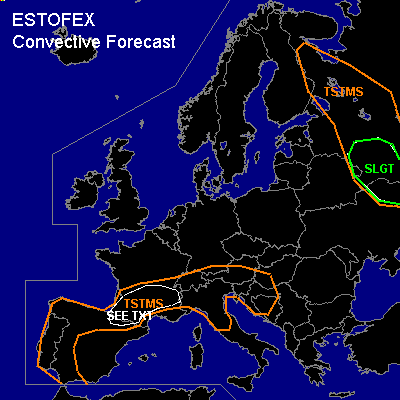
There is a slight risk of severe thunderstorms forecast across Wrn Russia
General thunderstorms are forecast across Wrn Iberia, Srn France, Nrn Italy/Alps/Balkan
SYNOPSIS
High pressure is building up over Wrn Europe. At present, a thermal trough is situated over Nrn Spain, Srn France into the Alps. Convergence, strong insolation and unstable stratification in this region favors thunderstorm development, initially on a local scale over orographic features. Tomorrow an approaching upper trough with associated cold front and organised lift is expected to set off more widespread convection in about the same areas, while also deep layer shear increases.
In far eastern Europe, a low pressure system with strong pressure gradients will leave the forecast area tomorrow.
DISCUSSION
...Srn France...
12Z Bordeaux sounding featured more than 600 J/kg MLCAPE. Although shear is not present for serious storm organisation, dry midlevels will favor cold downdrafts and thereby enhance potential for strong gusts and large hail reaching the surface.
Dry midlevels are also present elsewhere throughout the TSTMS area, e.g. Italy, posing some threat of strong gusts, however with less CAPE and hence less certainty of storm sustenance.
...Wrn Russia...
14Z/15Z IR imagery shows development of convection behind cold front associated with the low pressure area. Steep low level lapse rates and some CAPE on just received soundings in that region (Kursk), low LCLs and strong deep layer and low level shear (25 m/s and 13 m/s respectively on Kursk sounding) pose a threat of rotating updrafts favoring large hail and a few tornadoes.
#