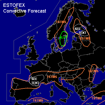

CONVECTIVE FORECAST
VALID 06Z WED 19/05 - 06Z THU 20/05 2004
ISSUED: 19/05 00:57Z
FORECASTER: GROENEMEIJER
There is a slight risk of severe thunderstorms forecast across southeastern Sweden
General thunderstorms are forecast across northern Spain, parts of France, northern Italy and the southern Alps as well as the extreme northern Balkans and the northeastern Balkans.
General thunderstorms are forecast across parts of Scandinavia, extreme western Russia, northern Belarus and northeastern parts of the Baltic States.
General thunderstorms are forecast across Crete, the southern Aegean Sea and southern turkey.
General thunderstorms are forecast across extreme southern parts of the western Mediterranean Sea.
SYNOPSIS
Wednesday at 06 Z... a westerly polar jet will be moving further eastward into Scandinavia. South of the jet a high pressure system is located over southern France. An mid/upper-level trough along a line from the northern Black Sea to Crete to northeastern Libya is slowly moving eastward.
DISCUSSION
...Sweden...
In the left exit region of the polar jet moving eastward over the region, surface pressure falls are expected over central Sweden that cause a strong low-level wind field on its southern flank. Some CAPE should be able to form both near and behind a surface cold-front that moves southeastward over southern Sweden during the morning and early afternoon hours. Given that 0-1 kilometer wind shear is expected to be in the 10-18 m/s range and deep-layer shear will be in excess of 20 m/s near the front, linearly organised convection is expected along the front that may contain few short-lived rotating updrafts while bowing segments may develop as well. The convection could locally be associated with wind gusts in excess of 25 m/s - and given that LCL/LFC heights will be low at the cold front - a tornado or two cannot be ruled out. Behind the cold front, some additional convective showers may form, but these should have a negligable severe threat.
...southern Finland, St Petersburg adm. region, Novgorod adm. region, northern Pskov adm. region, northeastern Estonia...
A few convective storms may form if a few 100's of J/kg MLCAPE form over the area, as indicated by the GFS model. Deep-layer shear should be near 20 m/s allowing for the formation of strong multicells, and possibly a short-lived rotating updraft or two. A chance of some larger hail and a few strong gusts will be present over the area. Given the marginal instability, the threat appears to be too low to warrant a risk category.
...southern France...
Diurnal heating will likely be able to cause 500-1000 J/kg to form over the region. Convection is expected to be mainly confined to mountain regions and their vicinity, as decending motions will likely inhibit convective development elsewhere. Dry mid-levels will likely remain present, indicating a potential of downbursts creating strong thunderstorm gusts. A risk of some large hail will also exist with the storms. Both hail and gusts should be of a very local nature so that issuance of a risk category seems not to be required at this moment.
#