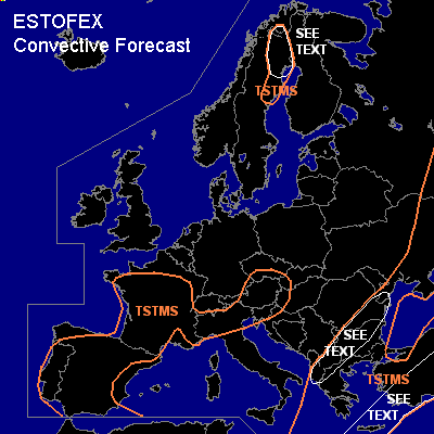

CONVECTIVE FORECAST
VALID 06Z TUE 18/05 - 06Z WED 19/05 2004
ISSUED: 17/05 21:58Z
FORECASTER: GROENEMEIJER
General thunderstorms are forecast across much of France, Spain, the Alpine countries, northern Italy and parts of central Europe.
General thunderstorms are forecast across parts of northern Scandinavia
General thunderstorms are forecast across the southern and Eastern Balkans, Greece, Turkey, central and eastern Ukraine and southwestern Russia
SYNOPSIS
Tuesday at 06Z.. a high pressure area is located over western France. On its northern flank, a westerly jet is moving eastward into Scandinavia. A NE-SW oriented trough is located from western-Russia to the southern Balkans and is expected to move eastward very slowly.
DISCUSSION
...southern and eastern Balkans...
It seems as though a little MLCAPE may develop east of the aformention trough, that - at the surface- coincides with a poorly developed cold front. As deep-layer (0-6 km) shear is expected to be around 20 m/s, some organised storms may develop, capable of producing some large hail. The very limited instability precludes the issuance of a risk category.
...Crete, southern Agean, southern Turkey...
A few 100's of J/kg MLCAPE are predictyed by the GFS model tomorrow in the area. Deep-layer (0-6 km) shear is expected to be around 20-25 m/s, so that convective storms may locally organise into severe multicells and perhaps a few supercells capable of producing some large hail and gusty winds. The overall severe threat is forecast to be quite low given the meager instability, so that a risk category seems not to be warranted.
...northern Sweden, extreme northwestern Finland...
Some organised convection could be possible Tuesday morning and early afternoon within the indicated area as a few 100's of J/kg MLCAPE could form where deep-layer shear exceeds 20 m/s. A couple of strong wind gusts, but likely below severe levels can be expected.
#