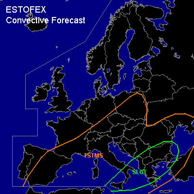

CONVECTIVE FORECAST
VALID 06Z THU 13/05 - 06Z FRI 14/05 2004
ISSUED: 13/05 06:27Z
FORECASTER: GATZEN
There is a slight risk of severe thunderstorms forecast across eastern Mediterranean
General thunderstorms are forecast across eastern Europe ... northern Mediterranean ... southern Iberian Peninsula
SYNOPSIS
Upper trough placed over Europe evading into western Mediterranean. Ridge extends into NWern Europe. Relatively cold airmass has entered the forecast region. At the surface ... low pressure remains in the Mediterranean ... while high is forecast over Central Europe.
DISCUSSION
...Eastern Mediterranean
...
Embedded jet streak will move across the eastern Mediterranean today ... and UVM is expected. Affected airmass will be slightly unstable due to latest ascends showing rather rich low-level moisture and convectively mixed airmass aloft. GFS suggest CAPE up to some hundred J/kg during the day. Thunderstorms should form, and rather strong deep layer wind shear should be sufficient for organized thunderstorms. Large hail and damaging wind gusts will be the main severe threat. Low-level wind shear is expected to remain quite low and low-level SRH should be weak. However ... as LCLs will be low ... a few tornadoes are not ruled out attm.
...Eastern Europe ... northern Mediterranean ... southern Iberian Peninsula...
Underneath the trough axis ... sufficient instability shoud develop in the cold airmass due to diurnal heating. Weak deep layer shear is forecast and severe thunderstorms are not likely.
#