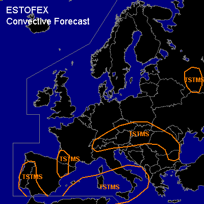

CONVECTIVE FORECAST
VALID 06Z WED 12/05 - 06Z THU 13/05 2004
ISSUED: 12/05 00:30Z
FORECASTER: VAN DER VELDE
General thunderstorms are forecast across SW Iberian Peninsula
General thunderstorms are forecast across SW France
General thunderstorms are forecast across Central Europe and Nrn Balkan
General thunderstorms are forecast across Central Mediterranean and Srn Italy
General thunderstorms are forecast across SW Russia
SYNOPSIS
Upper air pattern is characterized by a large shallow trough over central/eastern Europe. Upper ridge over the Atlantic approaches Western Europe.
WAA over the Wrn Mediterranean near upper low caused development/deepening of a SFC low that will migrate over Cntrl Med to affect the Balkan by the end of the FCST period and the following day. Blocking high SFC pressure stretches out all the way from NW Spain towards northern Scandinavia. A northerly flow will advect cooler air into much of Wrn Europe between this high and the Mediterranean low. Because of this, the band of high theta-e over central Europe with associated convective potential will be pushed somewhat southward.
Near-surface convergence zones and small vorticity maxima in high theta-w provide focuses for convection over the European mainland, while WAA and UVVs ahead of the low will cause primarily elevated convection over the Mediterranean. The best deep layer/low level vertical shear conditions seem to be mostly outside the convective areas. Hail and gusts may occur, but are not expected to reach severe criteria.
A synthesis of BOLAM 21km and GFS CAPE/LI and SFC convergence is used to indicate TSTMS areas.
DISCUSSION
#