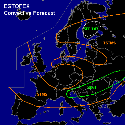

CONVECTIVE FORECAST
VALID 06Z FRI 07/05 - 06Z SAT 08/05 2004
ISSUED: 07/05 01:33Z
FORECASTER: GATZEN
There is a slight risk of severe thunderstorms forecast across northern Mediterranean into eastern Europe
General thunderstorms are forecast across northern Central Europe
General thunderstorms are forecast across northeastern Scandinavia
SYNOPSIS
Upper high over northern Europe ridges westward, and western European long-wave trough diggs eastward. Along the southern edge of this trough, strong jet present over the Mediterranean spreads ENE-ward into southeastern Europe at the end of the forecast period. Over northern Central Europe ... weak short-wave trough moves westward.
DISCUSSION
...Northern Mediterranean into eastern Europe...
Along the southern edge of the European trough ... strong jet stream will remain from northern Mediterranean into southeastern Europe. Embedded jet streak and associated vort-max will reach the northern Black Sea during the forecast period. At low levels
low pressure system will reach Romania during the day. Coupled cold front will reach the Black Sea on late Friday. Ahead of this cold front
rather moist airmass is present, and diurnal heating should allow for CAPE around 500 J/kg. Approaching upper vortmax and low-level convergent flow ahead and along the cold front should provide sufficient uvm to initiate thunderstorms. Within the cold airmass west of the front
model output suggests weak CAPE underneath the upper trough centre. Diurnal heating should allow for showers and thunderstorms. Increasing vertical wind shear north of the jet streak seems to support organized convection. Multicells may form and some storms may rotate producing large hail and damaging wind gusts. Threat for tornadoes should be enhanced as well.
Another vort-max is forecast that reaches the northern Balkans Saturday morning. Relatively strong synoptic forcing should be associated with this feature and model output shows a surface low associated with this feature. However
weak instability will be present during the night hours
and strong thunderstorms should be not likely.
...Northern Central Europe...
Cold airmass is expected to spread northward over eastern Germany. To the north
thunderstorms should form in the unstable warm airmass due to diurnal heating and weak DCVA in the range of the upper short-wave trough. Vertical wind shear will be greater than today. However
rather weak instability and weak forcing are expected and severe potential should be too low to warrant a SLGT RISK. If strong thunderstorms will form, marginally severe hail and strong wind gusts should be the main threat.
...Northeastern Scandinavia...
Unstable warm airmass remains in the range of the Scandinavian ridge. During the day
thunderstorms should form. Relatively weak forcing and weak vertical wind shear should not support organized convection. Due to relatively high CAPE values around 1000 J/kg
chance for strong thunderstorms producing large hail and strong wind gusts will be enhanced.
#