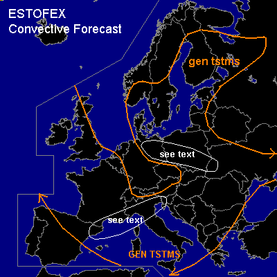

CONVECTIVE FORECAST
VALID 06Z THU 06/05 - 06Z FRI 07/05 2004
ISSUED: 06/05 01:07Z
FORECASTER: GATZEN
General thunderstorms are forecast across northern Central Europe
General thunderstorms are forecast across northeastern Scandinavia
General thunderstorms are forecast across Mediterranean
General thunderstorms are forecast across Western Europe
SYNOPSIS
Intense and unusual strong upper long-wave trough placed over western Europe, while upper high ridges from eastern Europe to Scandinavia. A very strong jet streak extends from southern Greenland to southern Iberian Peninsula and into the western Mediterranean. Another strong jet streak was analyzed from northern Africa to southeastern Europe. East of the western trough ... warm and unstable airmass is advected into eastern and northern Europe. Over western Europe ... cold airmass spreads into the Mediterranean. Frontal boundary is expected to reach from southeastern Europe to southern Poland, central Germany and further to western Scandinavia.
DISCUSSION
...Northern Central Europe
...
Well defined central European frontal boundary will move westward north of 50N ... and unstable airmass will be advected into Poland, northern Germany and southern Scandinavia. To the west ... strong warm air advection will lead to synoptic forcing, and stratiform rain and embedded thunderstorms are expected. East of the frontal boundary ... warm airmass should become unstable due to diurnal heating and increasing low-level moisture. During the day ... upper negatively tilted short-wave trough moves northward. Synotic forcing will be weak due to poor upper level wind speed. However ... weak convective inhibition is expected and thunderstorms should form during the day. Weak vertical wind shear does not support organized convection. Best chance for some rotating storms is expected from southern and central Poland to northern Germany, where low-level wind shear will be enhanced north of the approaching cold front. Thunderstorms should merge into clusters later on after cold pools form in the well-mixed boundary layer. Intense rain, marginally severe hail and severe wind gusts should be the main threat.
...Northeastern Scandinavia
...
Underneath the eastern ridge ... airmass over northeastern Scandinavia will become unstable due to daytime heating and rather rich low-level moisture. Tomorrow ... thunderstorms are expected. Weak vertical wind shear and weak synoptic forcing will not support organized convection.
...Mediterranean
...
Underneath the strong westerly flow ... cold air advection is expected during the forecast period. At low levels ... cold front will cross the central Mediterranean reaching the southern Balkans on Thursday evening. East of this front, rather dry and stable airmass is forecast. If thunderstorms may form ... severe potential seems to be quite high due to strong vertical wind shear. Over the northern Mediterranean ... cold airmass should be deep enough to allow for thunderstorms. Synoptic forcing ahead of upper short-wave trough and strong deep vertical shear may support some organized thunderstorms like short bows or multicells. Overall threat seems to be too low to warrant a categorical risk though.
...Western Europe
...
Deep polar airmass will remain over western Europe. Underneath the cyclonal flank of the upper jet ... showers and thunderstorms should be likely. Wind gusts and small hail will be the main severe threat. To the south ... increasing deep vertical wind shear may support some organized storms with severe wind gusts the main threat.
#