CONVECTIVE FORECAST
VALID 06Z TUE 04/05 - 06Z WED 05/05 2004
ISSUED: 03/05 22:14Z
FORECASTER: HAKLANDER
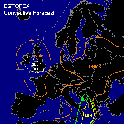
There is a moderate risk of severe thunderstorms forecast across the Ionean Sea, parts of the Albanian and Greek Ionean coasts.
There is a slight risk of severe thunderstorms forecast across extreme S'rn Italy, and the S'rn Adriatic Sea.
General thunderstorms are forecast across Ireland, the United Kingdom, and W'rn France.
General thunderstorms are forecast across S'n Sweden, Denmark, NE'rn Germany, Poland, the Baltic States, Belarus, parts of Ukraine, parts of the Czech Republic and Slovakia, N'rn and Central Italy, and the N'rn Balkan.
SYNOPSIS
An upper trough across the N'rn British Isles slowly digs S'ward during the forecast period. The associated NW'ly Atlantic 300 hPa jet of locally 150+ kts migrates SE'ward towards Spain. In the left exit region of this jet, strong cyclogenesis is taking place across the NW'rn British Isles at the start of the forecast period. The surface cold front of this low should lie across Wales at TUE/06Z, after which it sweeps further S- and W'ward as the frontal curl unfolds. At WED/06Z, the cold front should be situated from the N'rn Iberian Peninsula across the W'rn Alps towards W'rn Germany. Across the Ionean Sea, the development of an intense baroclinic zone directs the African jet NEward towards Greece. Severe convective weather is expected in association with a shortwave baroclinic disturbance below the left exit region of the African jet.
DISCUSSION
...Sicily, S'rn Italy, Ionean Sea and SW'rn Balkan...
A theta-e plume from Africa at low levels is expected to intensify in the second half of the forecast period. This plume is associated with the warm sector of a baroclinic wave that should develop across NWrn Libya and move NEward. Above the boundary layer, steep lapse rates are expected to build between 700 and 500 hPa, enabling the formation of about 1000 J/kg MUCAPE, according to GFS/12Z. Not only GFS/12Z, but also BOLAM/00Z calculated this amount of CAPE. Showalter Index values < -5K indicate that there is a deep layer to fuel the convection. After TUE/18Z, a strong SSW'ly low-level jet at 850 of 27 m/s should migrate N'ward towards the E'rn Ionean Sea. Owing to the strong low-level warm air advection, veering winds with height should yield about 400 m²/s² 1000-700 hPa SREH, according to GFS/12Z. Along with very strong 0-6 km bulk shear of about 30 m/s and 0-1 km shear of 14-18 m/s, the development of (elevated) supercells along and ahead of the cold front seems likely. Considering the amounts of CAPE, wind shear and synoptic forcing, very large hail with 2-6 cm diameter, severe convective windgusts of >100 km/h and one or two tornadoes are possible. The area of largest severe weather threat should be at or close to the Greek Ionean coast by WED/06Z.
...Ireland, S'rn British Isles...
Along the cold front at TUE/06Z, a low-level WSW'ly jet of 20-24 m/s at 850 hPa is forecast, along with 12-14 m/s 0-1 km shear. This should result in 300-350 m²/s² 1000-700 hPa SREH. Although hardly any CAPE is forecast, very strong forcing is expected below the left exit of the aforementioned jet and above a low-level convergence zone along the surface cold front. If embedded (thunder)storms form, they might acquire a short-lived rotating updraft. Given very moist profiles (LCL's at a few hundred metres AGL) and high 0-1 km shear, a tornado cannot be ruled out if CAPE manages to build. Severe wind gusts due to downward transport of momentum are a possibility as well. Stability is the key issue here, and since hardly any CAPE is forecast, we refrain from issuing a SLGT for the time being.
#