CONVECTIVE FORECAST
VALID 06Z WED 28/04 - 06Z THU 29/04 2004
ISSUED: 28/04 08:57Z
FORECASTER: GROENEMEIJER
General thunderstorms are forecast across Much of west-central, southwestern and central Europe
General thunderstorms are forecast across parts of Turkey
General thunderstorms are forecast across parts of the Russian Federation
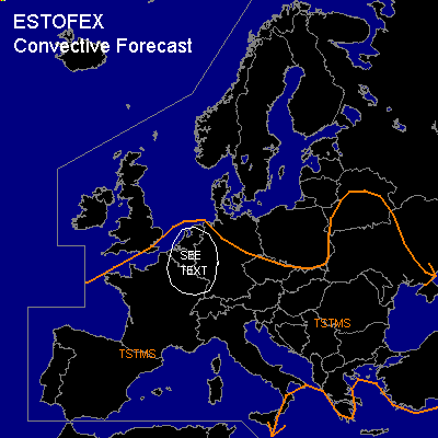
SYNOPSIS
Wednesday at 06... a vertically stacked low is expected to be located over western France. A relatively weak westerly jet streak on its southern flank is expected to rotate into southwestern and central France.
DISCUSSION
...France, Benelux...
About 400-800 J/kg MLCAPE should be able to form over the Benelux countries and northern France as diurnal heating destabilises the air-mass. Quite extensive cloudiness is expected to limit destabilisation over south-central France, while drier and cooler maritime air is expected to limit destabilisation in western France. As the aformentioned jet streak moves northward, a small area of relatively strong deep layer shear / 15-25 m/s / may coincide with some MLCAPE in the area marked "see text". Uncertainty whether this will actually be realised and relatively benign forcing for upward vertical motion makes that a slight risk will not be issued at this moment.
Further north, over northern France and the Benelux countries shear will be smaller, but MLCAPE will likely become higher. A few large hail events and strong, but likely sub-severe gusts will be possible here.
#